Image: NOAA/National Weather Service Weather Prediction Center
A cold front pushing across the Upper Midwest and Plains on Saturday is set to end a run of record-breaking November warmth, swapping temperatures in the 60s and 70s for showers, thunderstorms and, in the north woods, snow by Sunday.
The warmth peaked Friday, when temperatures climbed far above normal from Nebraska to the Great Lakes. The National Weather Service office in the Twin Cities said Minneapolis-St. Paul reached 65 degrees, breaking the Nov. 20 record of 63 set in 1925.
In Wisconsin, Milwaukee reached 67 degrees, breaking a record of 66 that had stood since 1897, the weather service office in Sullivan said. Madison hit 66, topping the old mark of 65 from 2003.
The weather service in Green Bay said Green Bay reached 66 degrees, smashing the record of 62. Oshkosh also hit 66, breaking a record of 65 from 2003, while Wausau reached 64, 4 degrees above its old record. Wisconsin Rapids tied its record of 68 from 1920.
Records also fell in the far north. The weather service in Duluth said International Falls, Minnesota, reached 52 degrees, breaking the 1963 record of 50. Hibbing reached 56, breaking a record of 52 from 1982, and Ashland, Wisconsin, hit 64, topping a record of 62 set in 1925.
Chicago’s O’Hare International Airport tied its record high of 68 degrees from 1930, the weather service in Chicago said. Toledo, Ohio, tied its record of 71 from 1942. On the western Plains, Imperial, Nebraska, reached 76, breaking a record of 75 set in 1897, according to the weather service office in North Platte.
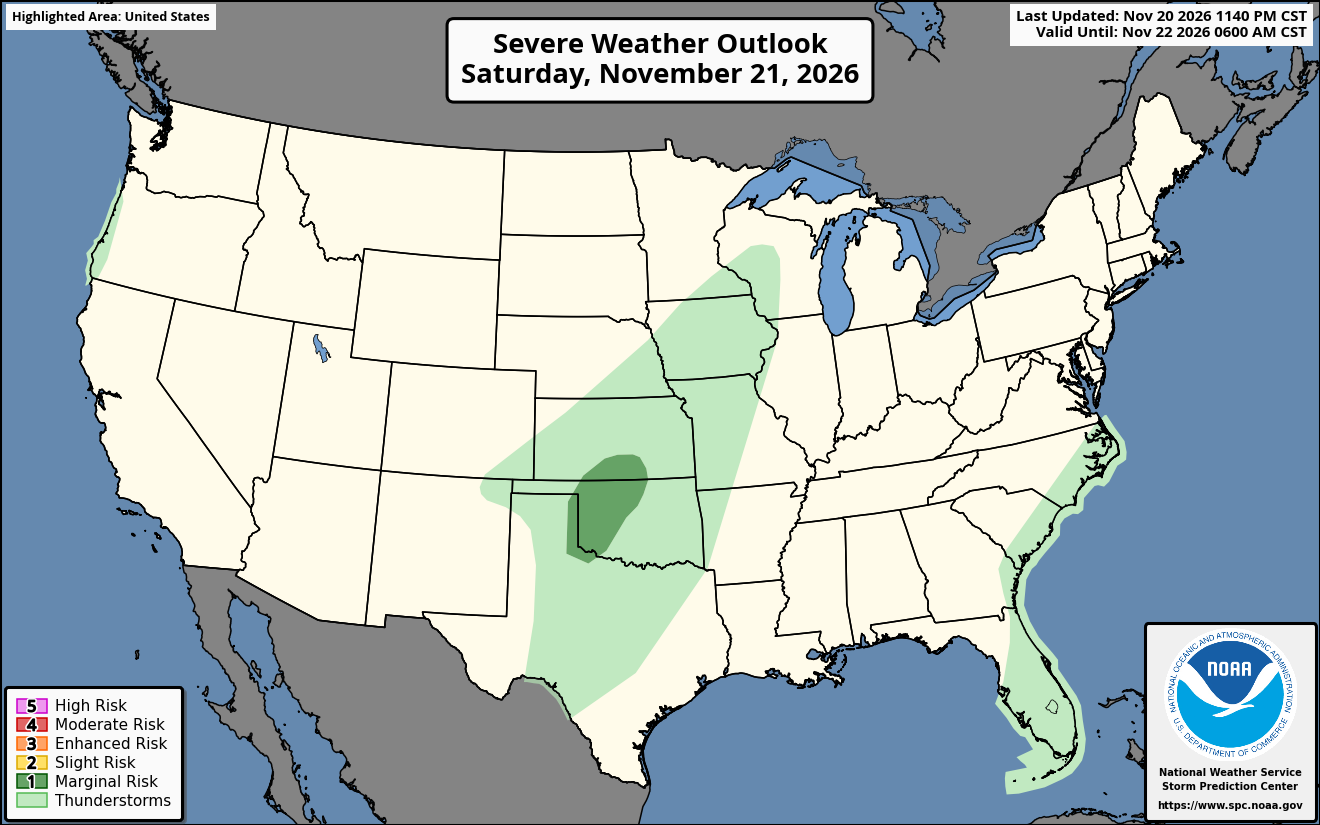
Image: NOAA/National Weather Service Storm Prediction Center
Warm Nights, Too
The warmth did not let up after dark. Sioux Falls, South Dakota, recorded a low of just 48 degrees Friday, breaking the record warm low of 43 set in 2003, the weather service in Sioux Falls said. The office noted that the normal high for Nov. 20 in Sioux Falls is 43 degrees and the normal low is 23, meaning Friday’s low was warmer than a typical high.
The weather service in Hastings, Nebraska, said the low at Grand Island dropped only to 51 degrees, breaking the Nov. 20 record warm low of 50 set in 1990. In Hastings, the low of 52 broke the record warm low of 41 from 2023. Watertown, South Dakota, set a record warm low of 42, the weather service in Aberdeen said.
All the figures are preliminary until reviewed by the National Centers for Environmental Information.
Front Brings Rain and Storms
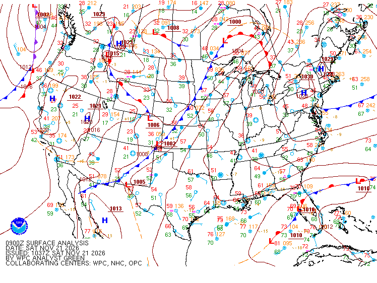
By early Saturday, the cold front stretched southwest from a low near the Minnesota-Canada border through western Minnesota, the Twin Cities weather service said. Temperatures ahead of it were still in the upper 50s to low 60s before dawn, and forecasters said those readings would likely be the day’s highs as the front moved east.
The office expected scattered rain showers across Minnesota on Saturday morning, with a second round moving in from the south later in the day. Western Wisconsin had the best chance of seeing half an inch to three-quarters of an inch of rain, while areas near Interstate 35 were expected to get a tenth to a quarter of an inch.
Farther south, the Storm Prediction Center said isolated strong to severe storms were possible from western Oklahoma into south-central Kansas on Saturday, and it placed that area under a marginal risk, level 1 of 5. The center said limited instability should temper the threat.
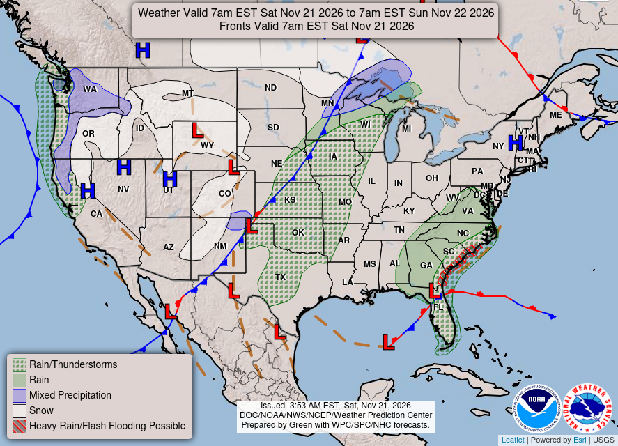
Image: NOAA/National Weather Service Weather Prediction Center
The weather service in Norman, Oklahoma, said a first round of showers and storms would develop in western Oklahoma by early afternoon and race northeast toward the Interstate 35 corridor by late afternoon. Severe weather is unlikely with that round, forecasters said, but the strongest storms could produce cloud-to-ground lightning, hail up to the size of quarters and wind gusts over 50 mph.
A second, more widespread round is expected Saturday night as the front surges south. The Norman office said the risk of marginally severe hail, from nickel to half-dollar size, would be greater with that round because of increased instability. Rainfall should generally stay below half an inch, the office said.
In Kansas, the weather service in Wichita forecast highs in the upper 60s to around 70 on Saturday before rain and thunderstorms developed by midafternoon along the front. A few storms could produce gusty winds and small hail, mainly in south-central Kansas, but widespread severe weather is not expected, the office said.
Snow and Squalls Up North
Behind the front, colder air is expected to change rain to snow in parts of northern Minnesota and northern Wisconsin on Sunday. The weather service in Duluth said it expected “one more warm day before seasonable temperatures arrive.”
The Duluth office said the chance of at least 1 inch of snow is 30% to 60% north of the Iron Range and in the lake-effect snow belts of northwest Wisconsin, rising to 60% to 80% in the higher terrain of Iron County, Wisconsin. Light lake-effect snow could linger along the South Shore into Monday morning.
Forecasters also flagged a 20% to 30% chance of snow squalls Sunday afternoon into early evening from north-central Minnesota into the Arrowhead. Air and road temperatures above freezing should limit travel problems during the day, the office said, but snow could stick to roads more easily after sunset. The main hazard would be brief, rapid drops in visibility.
Before the changeover, rain could be heavy at times in northwest Wisconsin, where the Duluth office put the chance of more than 1 inch of rain by Sunday morning at 40% to 50% east of a line from Hayward to Ironwood, Michigan.
The Weather Prediction Center said light snow would develop over parts of the Upper Midwest and Michigan’s western Upper Peninsula by Sunday evening.
Back to Normal, Then Below
The cooldown will return much of the region to typical late-November weather. The Twin Cities weather service said Canadian high pressure would settle over the northern Plains on Monday and Tuesday, with temperatures falling into the teens Monday. Forecasters noted that the colder air is close to normal for the time of year, and that milder-than-normal temperatures near 40 degrees are expected to return for much of the northern U.S. by midweek.
Image: NOAA/NESDIS/STAR
The Twin Cities office said a weak disturbance could bring a few snowflakes to western Minnesota early Wednesday, though dry air near the ground may keep it from reaching the surface. A stronger system could arrive late next week, but forecasters said it was too early to judge any snow impacts.
In Kansas, the Wichita office forecast highs in the 40s each afternoon from Sunday through Wednesday, with overnight lows in the 20s and 30s. The Norman weather service said temperatures will fall below average, with hard freezes possible each night next week in Oklahoma.
The Midwest and Plains are expected to stay mostly dry after the front passes. The Wichita office said dry conditions and mostly clear skies are expected from Sunday through Friday, with highs recovering to around 50 by late in the week.
Forecasters urged people with outdoor plans Saturday to watch for lightning and to check road conditions before traveling in northern Minnesota and Wisconsin on Sunday evening, when falling temperatures could allow snow to stick.
