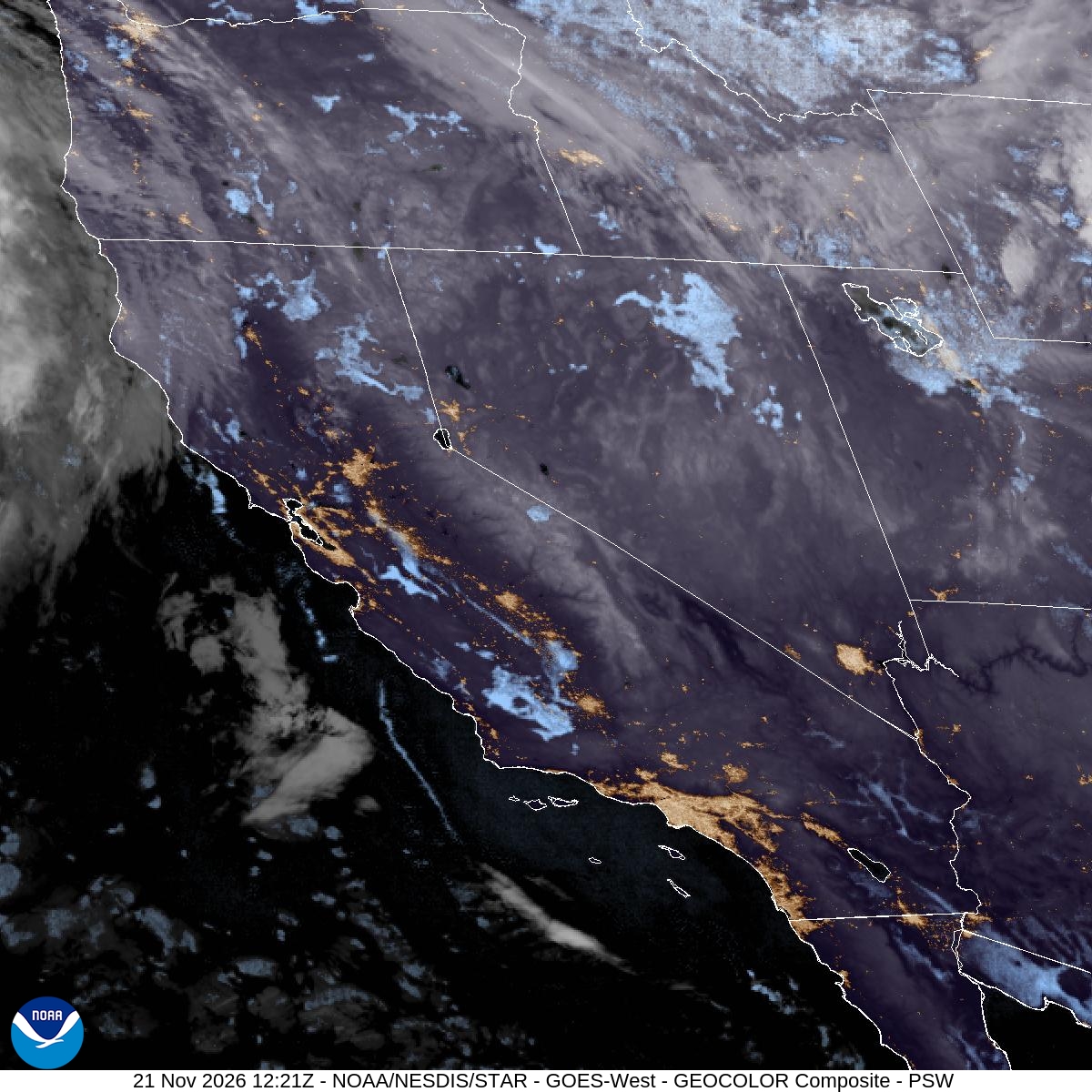
Image: NOAA/NESDIS/STAR
California’s coast is bracing for its highest tides of the season next week, with forecasters warning that king tides, a storm surge, large surf and a Pacific storm could combine to flood low-lying roads and shoreline property from the redwood coast to San Diego during the busy Thanksgiving travel week.
The National Weather Service office in San Francisco issued a coastal flood warning for the San Francisco and San Pablo Bay shorelines that takes effect at 6 a.m. PST Monday and runs until 4 p.m. Thursday. A coastal flood advisory covers the same shorelines until the warning begins.
The agency said “significant coastal flooding with up to 3.0 feet of inundation above ground level is possible in low-lying areas near shorelines and tidal waterways.” It warned that high tides “will result in flooding of low-lying infrastructure, numerous road closures, and coastal erosion.”
The highest water is still days away, but the tides were already running above normal Saturday, when an advisory covered the bay shorelines through the morning high tide.
Tides Climb All Week
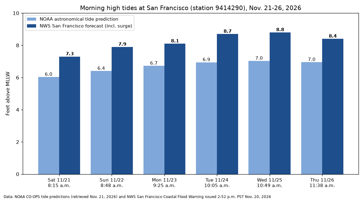
At the San Francisco tide gauge, the weather service forecast the morning high tide to reach 7.3 feet above mean lower low water at 8:15 a.m. Saturday, 1.5 feet above normal. Forecasters expect 7.9 feet Sunday, 8.1 feet Monday, 8.7 feet at 10:05 a.m. Tuesday and 8.8 feet at 10:49 a.m. Wednesday, 3 feet above normal. Thursday’s morning high tide is forecast at 8.4 feet.
Those forecasts include up to 1.8 feet of surge on top of the astronomical tide, the agency said. NOAA’s astronomical tide predictions for the San Francisco station, which do not account for weather, call for a morning high of about 7.03 feet Wednesday, showing how much of the forecast water comes from surge.
High tide can occur up to 90 minutes earlier or later along the Pacific coast and inside the bay, the weather service said.
King tides is a common term for the highest tides of the year, which occur around new and full moons, especially in winter. The moon will be full Tuesday.
A separate coastal flood advisory runs from 4 a.m. Saturday to 4 p.m. Thursday for the Pacific coast of the North Bay, including Point Reyes National Seashore, the San Francisco Peninsula coast and Monterey Bay south to Big Sur. That advisory warns of up to 3 feet of inundation in low-lying areas and isolated road closures.
In its forecast discussion Friday, the San Francisco office called coastal flooding “a concern through the weekend and a major concern into the next week,” with 2 to 3 feet of inundation possible during the peak of the tide cycle from Tuesday to Thursday. “Potential storm surge and rainfall runoff can exacerbate the impacts,” forecasters wrote. “Now is the time to prepare vulnerable properties.”
Source: NWS
From the Redwoods to San Diego
On the North Coast, the weather service in Eureka issued a coastal flood advisory for northern coastal Humboldt County, especially around Humboldt Bay, from 7 a.m. to 10 a.m. Saturday, with high tide at 8:31 a.m. at the Humboldt Bay North Spit gauge. Up to half a foot of saltwater was possible near shorelines and tidal waterways.
A coastal flood watch covers the Humboldt Bay area from Sunday morning through Thursday afternoon. Another watch covers coastal Del Norte County, southwestern Humboldt County and coastal Mendocino County from Tuesday morning through Thursday afternoon, warning that “high astronomical tides and large surf may cause moderate to major flooding in low lying areas along the Redwood/Mendocino Coast.”
The Eureka office said up to 2.5 to 3 feet of saltwater inundation is possible along that coast during the highest tides if strong southerly winds and large surf arrive at high tide. Several coastal roads may be closed, it said.
In Southern California, the weather service in Los Angeles issued a coastal flood advisory from 3 a.m. Monday to 3 a.m. Wednesday and a coastal flood watch from late Tuesday night through Thursday afternoon for beaches in San Luis Obispo, Santa Barbara, Ventura and Los Angeles counties and along the Malibu coast.
The agency said large breaking waves of 7 to 10 feet with dangerous rip currents will likely continue much of next week, peaking Wednesday and Thursday. It warned of “a moderate risk for damaging flooding of sea water over some vulnerable low-lying coastal areas, especially around the time of high tide, including over beaches, roads, and structures,” along with significant beach erosion and an increased risk of ocean drowning.
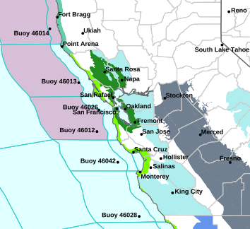
Image: NOAA/National Weather Service San Francisco Bay Area/Monterey
“Highest risk likely Wednesday and Thursday with potential for significant impacts,” the Los Angeles office said, adding that more products would likely be needed into Friday. A separate advisory covers the southwestern and southeastern Santa Barbara County coast and Catalina and the Santa Barbara Islands from 3 a.m. Monday to 3 p.m. Thursday, warning of moderate flooding over beach parking lots, bike paths and harbor walkways.
Farther south, the weather service in San Diego issued a coastal flood advisory from 4 a.m. Sunday to 4 a.m. Tuesday and a coastal flood watch from 4 a.m. Tuesday through Thursday afternoon for the Orange County and San Diego County coasts. It said morning high tides would exceed 7 feet by Sunday and reach 7.9 to 8.2 feet each morning Tuesday through Thursday, peaking Wednesday.
The San Diego office said surf of 3 to 5 feet would continue through Wednesday, but an incoming swell could bring notably higher surf beginning Thursday. It noted that its tide forecasts “have been adjusted above baseline astronomical predictions based on trends in recent observations.” Numerous roads may be closed and low-lying homes, businesses and some critical infrastructure may be inundated, the agency warned.
A Storm Arrives at the Peak
The flooding threat is complicated by another storm. The San Francisco office said Monday should be mainly dry, but another system is expected Tuesday into Wednesday “with more significant rainfall and wind concerns than the weekend system.” Widespread rain is expected to arrive Tuesday morning and continue into early Wednesday, with gusts of 40 to 50 mph possible along the coast, through gaps and passes and in the Salinas Valley.
“This system is also impacting during the King Tide cycle, and any rain runoff can exacerbate coastal flooding impacts, and impacts the Thanksgiving travel period,” forecasters wrote.
Light rain was expected to return to the Bay Area late Saturday, with a chance of rain Sunday.
Image: Eric from Berkeley via Flickr/Wikimedia Commons
Cities Urge Preparation
San Francisco officials urged businesses to prepare now. In a Nov. 20 notice, the city said the combination of high tides and heavy rain Tuesday and Wednesday “may mean that water that typically drains to the Bay will have nowhere to go,” which “could result in significant street flooding, even with less rainfall than this week’s storm.”
The city said San Francisco Public Works offers businesses up to 10 free sandbags before and during severe storms at its operations yard gate at Marin and Kansas streets, with posted hours of 8 a.m. to 2 p.m. Monday through Saturday. The city recommended that businesses clear leaves from drains from the sidewalk without lifting grates, raise inventory off the ground, review flood insurance and prepare for power outages. Residents can sign up for emergency alerts by texting their ZIP code to 888-777.
The weather service advised people in flood-prone areas to protect property and not drive around barricades or through water of unknown depth. Forecasters also urged beachgoers to stay off rocks and jetties, where large waves can sweep people into the ocean.
