After a rough day that brough flooding rains to portions of eastern Pennsylvania and the New York City metro area and a Tornado-warned storm in Burlington County, New Jersey, it looks like more rough weather is building in the northeast this afternoon. The National Weather Service’s Storm Prediction Center (SPC) is tracking storms growing along a cold front in the northeast now; some of these storms could turn severe and do damage tonight.

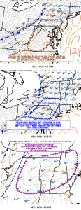
The Storm Prediction Center (SPC) has issued three Mesoscale Discussion Products for portions of the Mid Atlantic and Northeast this afternoon. The first is for a damaging wind and tornado threat over upstate New York, Vermont, and most of New Hampshire. The second is for the threat of wind damage and a slight risk of a tornado further south in northeastern Pennsylvania, northwestern New Jersey, and southeastern upstate New York. The third is for a wind damage threat over southwestern New Jersey, much of southern Pennsylvania, much of Maryland, and most of Virginia. Within these three areas, the region with the highest risk for severe weather is over northern New England; because of that, the National Weather Service is contemplating now whether to issue a Severe Thunderstorm Watch or Tornado Watch for the area now.
A warm, moist environment is in place across much of the Mid-Atlantic ahead of an approaching cold front that stretches south-southwest from western New York through western Pennsylvania/West Virginia. A smaller vorticity maximum is helping to provide ascent over the the region with thunderstorms now developing along the eastern edge of the Appalachians in Virginia and North Carolina. With less cloud cover over most of this area compared to farther north/west, temperatures have warmed into the 80s with dewpoints in the upper 60s to low 70s. There is enough instability to support thunderstorm development; with shear in Maryland, Pennsylvania, and New Jersey, a few rotating storms within a broken line of storms as we move into the evening. The SPC says a watch is unlikely given the overall marginal storm environment and isolated severe risk, but says that southern Pennsylvania and nearby areas could be included in a watch depending on storm evolution.
North of this area into northern Pennsylvania and New York, the SPC says storms should continue to develop and likely strengthen through the afternoon across central New York and northeast Pennsylvania. The SPC says strong wind gusts are likely and a brief tornado or two cannot be ruled out. “A watch issuance is possible with the forcing/shear present over the area even with the limited instability,” the SPC mentions in their Mesoscale Discussion.
The best area of wind damage and potential tornadoes remains over New England. According to the SPC, strong forcing for ascent along and ahead of the cold front will help overcome the modest instability and the expectation is for
gradually increasing storm intensity over the next few hours. “Kinematic environment is favorable for damaging wind gusts from momentum transfer as well as isolated mesovortices within any surging line segments,” says the SPC. They add that severe coverage is expected to be high enough to merit a watch.
Either Tornado or Severe Thunderstorm Watches could be issued for these areas in question. A Tornado Watch means conditions are favorable for tornadoes and severe thunderstorms in and close to the watch area. Persons in these areas should be on the lookout for threatening weather conditions and listen for later statements and possible warnings. Some warnings have already been issued for possible tornadoes spotted by observers on the ground or by National Weather Service weather RADAR. A Severe Thunderstorm Watch means conditions are favorable for severe thunderstorms in and close to the watch area. Persons in these areas should be on the lookout for threatening weather conditions and listen for later statements and possible warnings. Severe thunderstorms can and occasionally do produce tornadoes.