The National Weather Service’s Storm Prediction Center warns that beyond an expected severe weather outbreak today and tomorrow, a few tornadoes, scattered damaging winds, and isolated, small to marginal severe hail are possible Sunday across portions of the U.S. East.
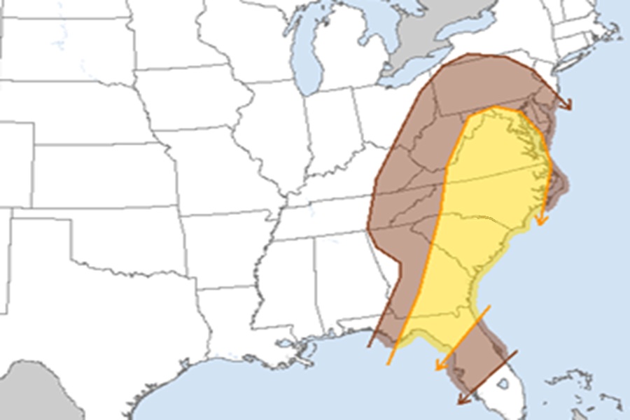
The latest Convective Outlook from the Storm Prediction Center (SPC) suggests an area stretching from northern Pennsylvania and central New Jersey south to northern Florida is at risk of severe weather on Sunday, with the greatest risk stretching from central Maryland through much of Virginia, North Carolina, South Carolina, southeast Georgia, and northeastern Florida.
According to the SPC, a strong low-level shear will remain coincident with at least mid 60s surface dew points to produce a downstream tornado and wind threat through late morning into the afternoon in the East. The southern portion of the convective band will encounter diminishing/more veered low-level flow with time, deeper in the Florida Peninsula. This should result in a predominantly isolated damaging wind threat by late afternoon.
North in the Mid Atlantic states, low-topped convection, that may not be producing much lightning, should be ongoing across parts of the central/southern Appalachians region by Sunday morning. Destabilization ahead of this activity will likely be muted by poor mid-level lapse rates and substantially weaker boundary-layer heating relative to the Florida Peninsula.
However, the Storm Prediction Center warns, With very strong low-level shear/winds, some risk for damaging winds and a couple tornadoes may be realized.”
The severe weather threat should diminish Sunday evening as the forecast frontal system moves out to sea.
