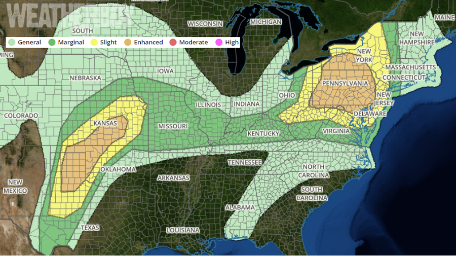
After a devastating night that saw numerous large, deadly tornadoes in portions of Missouri, including one that ravaged the state capital of Jefferson City, meteorologists are concerned for a fresh round of severe weather. Today’s severe weather outbreak is likely to occur in two regions: over portions of Kansas and Oklahoma again, and a new threat area in portions of the Mid Atlantic and Northeast. The National Weather Service’s Storm Prediction Center (SPC) is urging people in these areas to pay close attention to any Severe Thunderstorm Warning or Tornado Warning that may be issued; it may become necessary for people to act immediately to save their life from severe weather. In these danger areas, severe storms with large hail, damaging wind and tornadoes will be possible today and this evening.
Several ingredients are coming together to produce another round of severe weather over portions of Texas, Oklahoma, and Kansas. A cold front stretching from northern lower Michigan across central Illinois will become quasi-stationary southwestward over northern Oklahoma and the Texas panhandle. Some northward retreat of this front is possible today across Kansas with strong low-level warm advection. Farther northeast the front will be preceded by convective outflows. A dryline will mix eastward across the southern High Plains into the Texas Panhandle and South Plains regions this afternoon, before retreating westward tonight. As these meteorological components interact, severe weather will blossom. Dangerous thunderstorms with damaging winds, large hail, and tornadoes are possible here, with some intense tornadoes possible too.
In the Mid Atlantic and Northeast, scattered thunderstorms are expected through afternoon, moving eastward across the region, with damaging gusts, sporadic hail and the potential for a few tornadoes. Here, low-level warm, moist advection from the southwest is expected to combine with diabatic surface heating to destabilize the boundary layer across the region. Atmospheric conditions should be sufficient to support convective development, perhaps including an eastward shift/re-intensification of the ongoing arc of convection over portions of Ohio. A well-mixed sub cloud layer will support strong-severe thunderstorm winds, as well as maintenance to the surface of severe hail. Despite slightly veering to unidirectional winds with height, sufficient low-level and deep shear is forecast,
with a component orthogonal to the main belt of convective forcing, to support a blend of multicell and supercell modes. As such, isolated to widely scattered thunderstorms, could form behind the initial arc this afternoon as well, but the SPC believes sufficient destabilization and air-mass recovery to support an organized severe threat with this regime remains quite uncertain at this time.
The severe weather threat in both of these regions will diminish during the evening hours tonight. By tomorrow, the SPC believes there will be no widespread threat of severe weather across the country, kicking off the weekend on a much quieter note.
