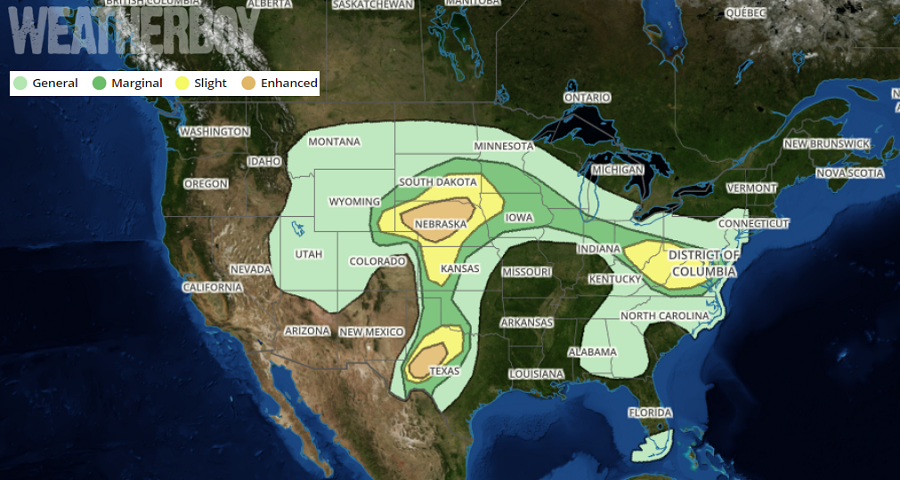
A severe weather outbreak is likely to unfold this afternoon, with three target areas across the country: portions of Nebraska, portions of Texas, and portions of the Mid Atlantic. The weather in Nebraska has the potential to be especially violent with an increased threat of large, powerful tornadoes there.
The National Weather Service’s Storm Prediction Center is tracking severe weather threats around the country today. Severe storms with very large hail, damaging winds, and a few tornadoes are expected, mainly from the central High Plains northeastward to the mid Missouri Valley. Several severe storms capable of producing very large hail and damaging winds, and a couple of tornadoes will also be possible across portions of the western half of Texas. Finally, scattered afternoon storms capable of producing locally gusty/damaging winds will be possible from Ohio through the Mid Atlantic region.
A variety of meteorological ingredients are coming together to create today’s severe weather outbreak. A large-scale upper trough over the western U.S. will shift eastward through Friday night as a pronounced jet streak becomes established over the central/southern Plains. A strengthening surface low over northeast Colorado and western Nebraska, along with the eastward progression of the upper trough, will result in strengthening low/mid-tropospheric wind fields and favorable deep-layer shear for organized/severe storms. A warm front will extend east from the surface low, transitioning into a cold front across the Ohio Valley/mid-Atlantic region, while a surface dryline extends southward across western portions of Kansas and Texas by late afternoon. Lower/mid-60s surface dew points will be transported northward , resulting in moderate/strong surface-based instability by afternoon.
A convective complex over West Virginia this morning should continue to weaken as it moves south/southeast within a weakly buoyant environment. Daytime heating will result in pockets of moderate surface-based instability near the front and west-northwest mid-level flow will result in sufficient shear to support organized storms. Frontal convergence should lead to additional scattered thunderstorm development during the day, with a risk for damaging gusts and perhaps large hail.
More severe weather is expected across the Midwest tomorrow as the weather system there marches east. Meanwhile, the threat for severe storms will dissipate across the eastern states.