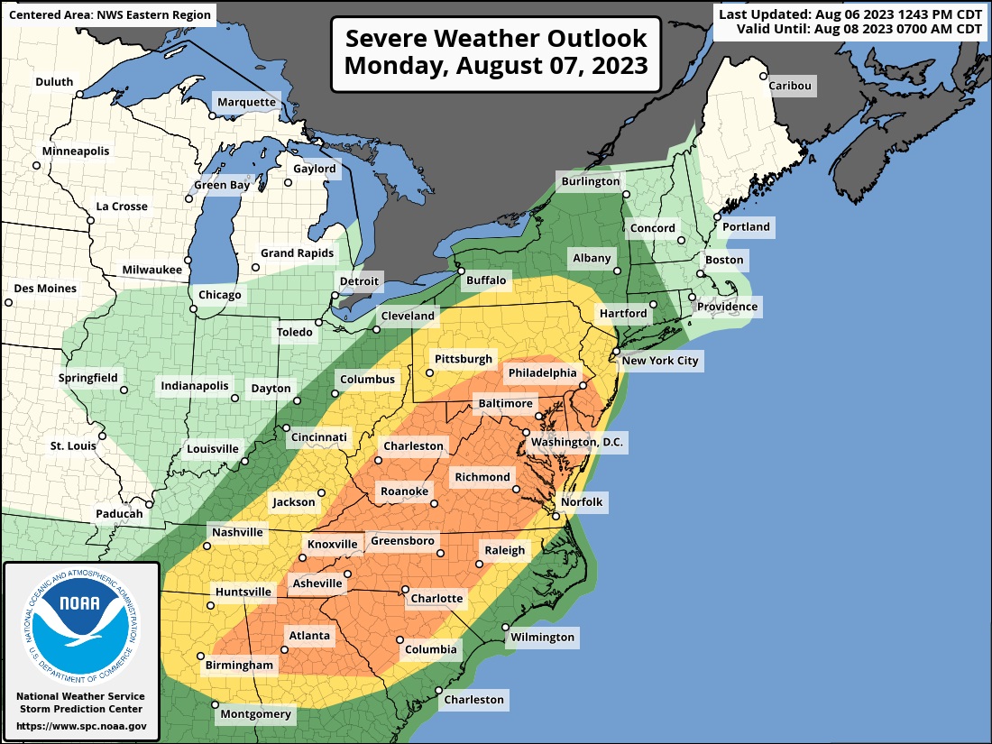
The National Weather Service’s Storm Prediction Center (SPC) is warning about a likely severe weather outbreak expected in a large part of the eastern United States tomorrow, with an elevated risk of tornadoes from Atlanta to New York City. In the latest Convective Outlook update issued by the SPC, they have identified a large area that could see severe storms, some with isolated tornadoes, across eastern Alabama, northern Georgia, much of North and South Carolina and Tennessee, eastern Kentucky and Ohio, all of Virginia, West Virginia, Delaware, Maryland, New Jersey, and Pennsylvania, and portions of New York.
Severe thunderstorms are expected Monday across portions of the southern Appalachians, mid-Atlantic and northeast U.S. According to the SPC, scattered swaths of damaging gusts are expected with this activity with the risk of isolated tornadoes. People in this region should be prepared to take action should the National Weather Service issue Severe Thunderstorm and/or Tornado Watches and Warnings.
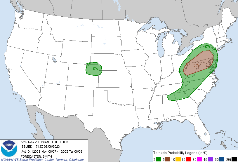
The greatest risk of tornadoes on Monday in the United States will be over portions of the Mid Atlantic, with southern Pennsylvania, southwestern New Jersey, northern Delaware, much of Maryland and West Virginia, and northern Virginia under the gun with the highest chances.
A variety of meteorological ingredients are coming together to create this severe weather outbreak. According to the SPC, a potent mid/upper level shortwave trough will move from Illinois to the central Appalachians during the day. A seasonally anomalous belt of strong west/southwesterly flow will move through the base of the trough and overspread the central/southern Appalachians into the Mid-Atlantic states. In the low levels, low pressure will develop east from northern Illinois to Lake Erie through evening. A cold front attendant to the surface low will sweep east and southeast across the Midwest during the day and reach the Appalachians and northern Mississippi and Alabama late overnight.

Scattered showers and isolated storms are forecast to be ongoing over the Ohio Valley Monday morning with more widely spaced convection trailing west-southwest into the Mid South and Ozarks. Considerable cloud cover with northward extent over a large moist/warm sector will limit destabilization of the atmosphere into portions of northern Pennsylvania and points north. But farther south, heating of a very moist boundary layer will yield a moderate to very unstable airmass from Pennsylvania and New Jersey southward into the southern Appalachians.

Multiple bands and clusters will likely begin to develop towards midday over the upper Ohio Valley and central Appalachians. Less certain, according to the SPC, will be the convective timing over the Tennessee Valley where a large spread of model solutions is currently depicted. Nonetheless, scattered thunderstorms will likely develop by early to mid afternoon and become quite extensive from northern Alabama and Georgia into Pennsylvania, Virginia, West Virginia, and Maryland. A mix of semi-discrete cells and clusters are possible initially and a risk for all severe hazards is expected given favorable shear profiles for storm organization and low-level rotation. Upscale growth is expected as storms move into the northern Virginia and Maryland and the Chesapeake Bay area during the late afternoon/early evening where the wind risk will seemingly be maximized. Much of the activity will eventually move east of the Mid-Atlantic coast during the evening and areas farther south through the Carolina Piedmont and into the coastal plain.
On Tuesday, there will be a lingering threat of severe storms over southeastern New England and the southeast U.S. coast. Otherwise, conditions will become more tame and calm where Monday’s active weather is expected to be.
