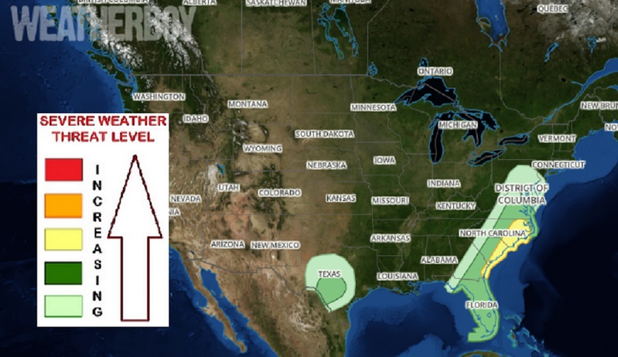
The National Weather Service’s Storm Prediction Center (SPC) is urging caution with severe weather in the forecast for the weekend; it’s possible that an outbreak of severe weather could occur in the East during midday and early evening hours on Saturday, especially across the Southeast and Mid Atlantic. The SPC says thunderstorms associated with wind damage and hail will be possible there, while a marginal severe threat could also develop in parts of Texas.
According to the SPC, an upper-level trough will become negatively-tilted in the Great Lakes on Saturday, as a cold front moves quickly eastward across the southern and central Atlantic coastal states. Ahead of the front, moisture and instability will increase during the day. Thunderstorms will likely form along and ahead of the front relatively early in the day due to forcing associated with the upper-level system and cold front. It appears that a line of thunderstorms will develop in the higher terrain, and move eastward across Virginia, the Carolinas and southeast Georgia during the afternoon. While thunderstorms are possible from Pennsylvania and New Jersey south to Florida, the greatest threat of severe storms will be over eastern North and South Carolina and Georgia.
In their latest Convective Outlook issued today, the SPC says that the conditions in the east should be favorable for a wind-damage threat, associated with fast moving multicell line segments. As storms gradually merge, a squall line is expected to form in the afternoon. This line will likely move into the western Atlantic during the early evening. While an isolated tornado can’t be ruled out, the primary threats will be wind and to a lesser degree, hail.
Further to the south across Florida, isolated thunderstorms are expected to develop during the day Saturday too. Instability is forecast to remain relatively weak, with large-scale ascent being limited. This should keep any severe threat marginal during the afternoon. A few strong wind gusts could occur with short multicell line segments.
Out west, a west-northwest mid-level flow will be in place across the southern Plains. At the surface, a cold front is forecast to move southward across west Texas. Ahead of the front, an axis of maximized low-level moisture is forecast to be in the Rio Grande Valley, where surface dewpoints could be in the lower 60s. Isolated thunderstorm development will be possible in parts of southwest Texas as surface temperatures warm during the day. The atmospheric ingredients coming together in southern Texas could be sufficient for marginally severe storms. The SPC says that hail and strong wind gusts are expected to be the primary threats in Texas.
