The National Weather Service’s Storm Prediction Center (SPC) is warning residents to be weather aware in the northeast as severe weather strikes there this afternoon and evening; New Hampshire, Maine, Massachusetts, Rhode Island, Connecticut, and far eastern New York are especially under the gun with severe weather threats.
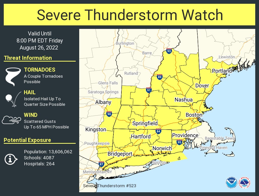
Due to the threat of severe storms, the National Weather Service has issued a Severe Thunderstorm Watch for the region until 8 pm tonight. The watch includes an area where more than 13.5 million people call home. Within this watch area, scattered wind gusts up to 65 mph are possible along with isolated hail up to quarter-size. The National Weather Service also says a couple of tornadoes are also possible within the watch area.
According to the SPC, embedded speed maxima will progress eastward from the lower Great Lakes to New England this afternoon, within the southern portion of a broad belt of cyclonic mid-upper flow over southeast Canada. At the same time, a weak surface cyclone will move eastward from the Saint Lawrence Valley to Maine by early tonight, as a trailing cold front moves southeastward across Pennsylvania, southern New York, and New England. As a result of this set-up scattered, slightly elevated thunderstorms continue in the northeast this afternoon in association with a lead shortwave trough. Surface heating and boundary-layer dewpoints in the mid 60s east of this convection and a pre-frontal trough will result in destabilization and will support surface-based thunderstorm development throughout the afternoon. Clusters and short line segments will subsequently spread eastward across New England in an environment of moderate buoyancy and vertical shear.

Into this evening, occasional damaging wind gusts will be the main threat from these storms. However, isolated large hail and isolated tornadoes are also possible.
While the current focus is on the southern and eastern portions of New England into this evening, the SPC also says that isolated strong cells may occur farther west across New York this afternoon, near and east of the cold front, with more veered low-level flow and weaker vertical shear.
The thunderstorms could also dump isolated heavy rain amounts. In much of the northeast, abnormally dry conditions persist with areas of severe to extreme drought in Massachusetts, Connecticut, Rhode Island, New Jersey, and New York. While today’s severe thunderstorm activity could help add moisture to the parched ground, it won’t be enough precipitation to bring an end to the drought conditions.
