The middle of the Memorial Day Holiday weekend will be stormy again, with severe weather likely across the Midwest and portions of the Mid Atlantic. Severe thunderstorms, including a few supercells with a risk for tornadoes, are expected today across much of the High Plains into the central Plains. Additional severe thunderstorms are possible across the lower Ohio Valley into the Mid Atlantic Coast region, accompanied mainly by a risk for severe wind and hail.
A large-scale pattern including persistent, prominent subtropical ridging centered near the eastern Gulf coast,and large-scale troughing within the mid-latitude westerlies across much of the West, will persist through the next 24 hours. Within the Western troughing, the most prominent perturbation, including a deep mid-level low, is forecast to dig inland of the California coast, to the south of San Francisco Bay, and into southern Colorado by Monday morning. As it does, models indicate that a downstream impulse will pivot northeast of Baja and accelerate across the southern Rockies through larger-scale ridging across the central High Plains. This likely will be accompanied by deepening surface troughing across much of the High Plains, and perhaps modest surface cyclogenesis from eastern Colorado into Nebraska late this afternoon through tonight, providing a focus for considerable strong to severe thunderstorm development.
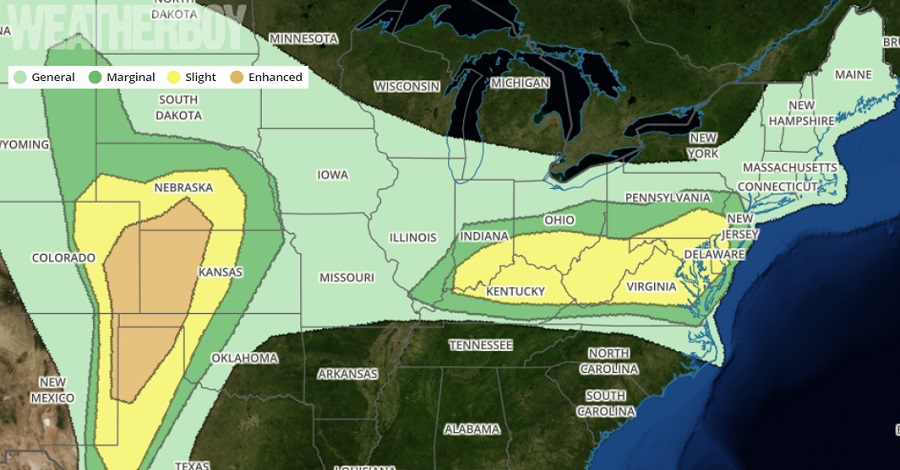
As has been the case for several days now, severe weather is likely from northern Texas into western Oklahoma and Kansas, eastern Colorado, and southern Nebraska. In this area, severe thunderstorms with large hail and/or damaging winds are likely. The threat of tornadic activity is also high in this region; people here should be prepared to take immediate action, day or night, should tornadic cells materialize.
Farther east, several convectively generated or enhanced perturbations will continue to migrate around the northern periphery of the subtropical ridge in the southeast, and are expected to aid convective development along and south of an initial surface front advancing southward into/through the Mid Atlantic coast region and Ohio Valley. Models indicate that seasonably high boundary layer moisture content ahead of the southward advancing front will become favorable for severe weather during the afternoon hours. With the right ingredients in place, the potential for organizing clusters of thunderstorm activity, aided by forcing and shear associated with the perturbations progressing around the northern periphery of the subtropical ridge are expected. Upper level winds layer may be sufficient to support occasional isolated supercells, but severe hail and wind appear the primary hazards in the region stretching from southern Indiana east to southern New Jersey.
