A significant storm along the coast of the eastern US will bring heavy rain, strong winds, and the threat of coastal and inland flooding. While many storms this time of year also produce a lot of snow, this storm is completely lacking much cold air to work with; as such, while some frozen and freezing precipitation is possible on the northern reach of this storm, plain rain will be the dominant precipitation type.
A complex area of low pres over the southern Plains and southeastern US is moving towards the east coast today. This storm will impact the east coast from later Sunday into early Tuesday, bringing a prolonged period of poor weather to a heavily populated region.
Computer forecast guidance that meteorologists use to aid in their forecasting is aligned around the idea that there will be soaking rain, strong winds, tidal flooding and beach erosion. While confidence is high with these individual elements, the timing and magnitude of such are less certain.
Wind
One of the most widespread and potentially damaging impacts from this storm will be wind. Due to that threat, the National Weather Service offices that serve New York City, New Jersey, Connecticut, and Massachusetts have issued a High Wind Watch for parts of their forecast areas. A High Wind Watch means the potential exists for a damaging wind event; strong winds from such an event are capable of downing trees and power lines as well as causing property damage. If this watch is upgraded to a Warning for your county, be sure to stay inside and away from windows and trees.

Across Cape Cod and nearby islands, winds of 35-45mph are expected with gusts up to 60; the greatest threat of wind damage there is late Monday morning through Monday night.
In New York City, the strong winds will arrive sooner: the greatest threat of winds, which should be in the 30-40mph range with gusts to 60mph, arrives Sunday evening and lasts through Monday evening. The National Weather Service office responsible for the New York City region warns, “Downed trees and power lines are likely, with numerous power outages possible. Travel could be difficult, especially for high profile vehicles, and on elevated roads and bridges.”
The High Wind Watch is also up for many counties in New Jersey; the National Weather Service there warns that high winds may extend far inland from the coast. While winds of 30-40mph and gusts to 60mph are possible along the coast, they warn, “Winds 20-30mph with gusts 40-50mph are possible farther inland along the I-95 corridor and in Delaware.”
Rain
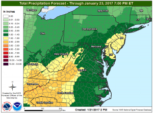
Heavy, soaking rains will also impact the eastern US as a result of this storm system. More than 3″ is possible in western Virginia and North Carolina, eastern Kentucky and Tennessee, and for a large part of South Carolina.
Further north, another pocket of heavy rain is expected over central and southern New Jersey, southeastern Pennsylvania, including the Philadelphia metro region, northeastern Maryland, and all of Delaware. In this pocket, 2″-3″ of rain are possible by the time the storm exits the region later on Tuesday.
Some downpours could create localized flash flooding concerns; remember, turn around, don’t drown! Never drive through flooded roadways.
The northeast is still dealing with severe drought conditions; while the heavy rain will be welcome, it won’t nearly be enough to wash away the drought conditions there.
Coastal Flooding & Beach Erosion
With strong winds, rough surf, and heavy rain, the beach communities in the Mid Atlantic and Northeast will take a beating from this storm. However, until more is known about the speed of the storm, the extent of flooding remains somewhat unknown as this time. Minor flooding is probable, especially along the ocean; but if the storm is stronger and slower, then moderate coastal flooding would be possible, especially along the ocean and back bays in central New Jersey. Strong onshore winds and battering waves could cause significant beach erosion, especially at the Jersey Shore and the south shore of Long Island. The National Weather Service says, “Confidence in the occurrence of at least minor tidal flooding is moderate.”
Wintry Precipitation
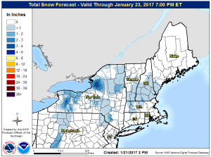
Wintry precipitation from this system will be limited to the northern fringes of the storm. While a light glaze of freezing rain is possible as far south as the highest terrain of northeastern Pennsylvania, any icing or sleet should change to plain rain fairly quickly. Further north where cold will be be difficult to scrub out of the mountains and valleys there, some light accumulating snow is possible across northern New England. But with a lack of cold air for this system to tap into, the dominant precipitation type in the eastern US from this storm will be plain rain.
Looking Ahead
Beyond this storm system, colder air will make its way to the eastern United States. A pattern change is expected as we move into February, with the wet and wintry weather pausing over the western United States and a colder, snowier turn occuring in the eastern United States. We have more on that pattern change here: Significant Pattern Change Arriving Soon.
