
Odds are increasing that the northeast coast will be battered by a significant coastal storm towards the middle to end of next week. Computer forecast guidance, such as the American GFS and the European ECMWF, have been suggesting for several days that there’d be enough moisture, energy, and cold air to work with to produce a sizeable storm along the Mid Atlantic and/or New England coast.
Now, overnight forecast guidance is somewhat in agreement that a storm system will take shape. However, there are still run-to-run and model-to-model forecast differences which inhibits a great deal of confidence on the extended forecast.
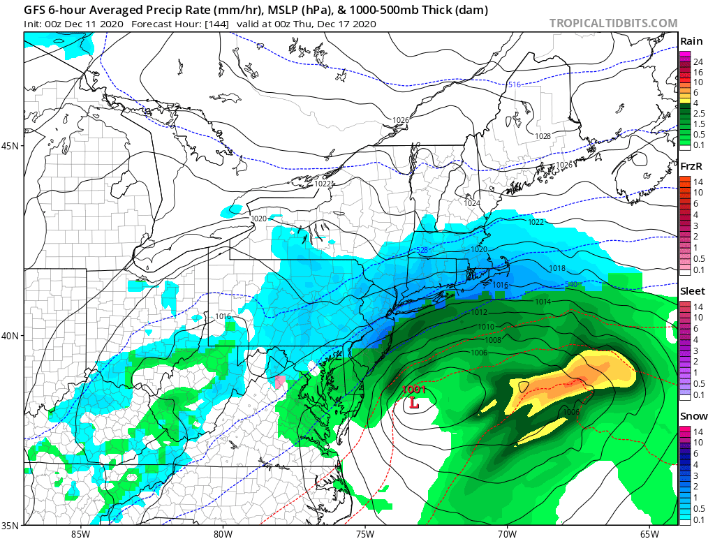
The latest American GFS forecast model depicts an area of low pressure forming off of the southeast coast late Tuesday / early Wednesday, eventually becoming an impressive storm in the northeast by Thursday. On Wednesday afternoon, it increases rain and wind over portions of Virginia, Maryland, Delaware, and southern New Jersey. However, on the northern end of the snow into central and northern New Jersey, eastern Pennsylvania, and the metro New York City area, it produces snow. On Wednesday night into Thursday morning, this snow picks up in intensity; it also changes rain to snow across southern New Jersey, northeastern Maryland, and northern Delaware. It also brings snow to southeastern New England, with the Cape Cod area hit by especially heavy snow and strong winds. The GFS suggests this storm would move north and east off-shore, ending all precipitation in the northeast by Thursday afternoon. Before the storm exits, it suggests a 3-6″ snowfall from Philadelphia to Boston along the I-95 corridor there, with less amounts north and west and less amounts south and east of there. However, the Cape Cod area could get even more snow, with this latest model run suggesting a 6-10″ snowfall accumulation possibility.
The latest European ECMWF forecast model depicts a somewhat different storm situation unfolding over the later part of next week. On Wednesday morning, it has one area of low pressure over the Mississippi Valley and another developing off of the southeast coast. By Wednesday evening, the lows merge into one substantial coastal storm over eastern Virginia. While the GFS keeps the center of the storm off-shore, the ECMWF puts it right on the coast. And unlike the GFS, the ECMWF takes the storm system up into New England rather than out to sea, producing much more precipitation and wind. The latest European model drops much more precipitation than the American model, but it also shifts the rain/snow line further inland. Unlike the American GFS which eventually brings snow to southern New Jersey, the latest European ECMWF keeps accumulating snow north and west of the I-95 corridor from central Virginia to central New Jersey. North of here in northern New Jersey, northeastern Pennsylvania, southern upstate New York, and southern New England, the European model suggests very heavy snow. The area near and just north and west of Philadelphia and New York City would see 6-12″ while areas north of there, in the Poconos and Catskills, could see more than a foot of snow if this model were to verify. It also suggests around a foot of snow for much of Connecticut, Rhode Island, and Massachusetts, with Boston seeing a foot or more of snow too.
Because of the vast difference between these model solutions, it’s too soon to put much weight behind either. While it is becoming more and more clear than a storm system will develop in the eastern United States during the middle to later part of next week, it’s too early to say who will get snow, who will get rain, or who will get both. And it is too early to know with certainty how much precipitation each area will receive.
As more weather data is captured this weekend into the early part of next week, though, clarity will arrive on how this storm will evolve. Before then, people in the eastern U.S. should prepare for the possibility of a coastal storm and the threat of more wind-whipped rain or snow.
