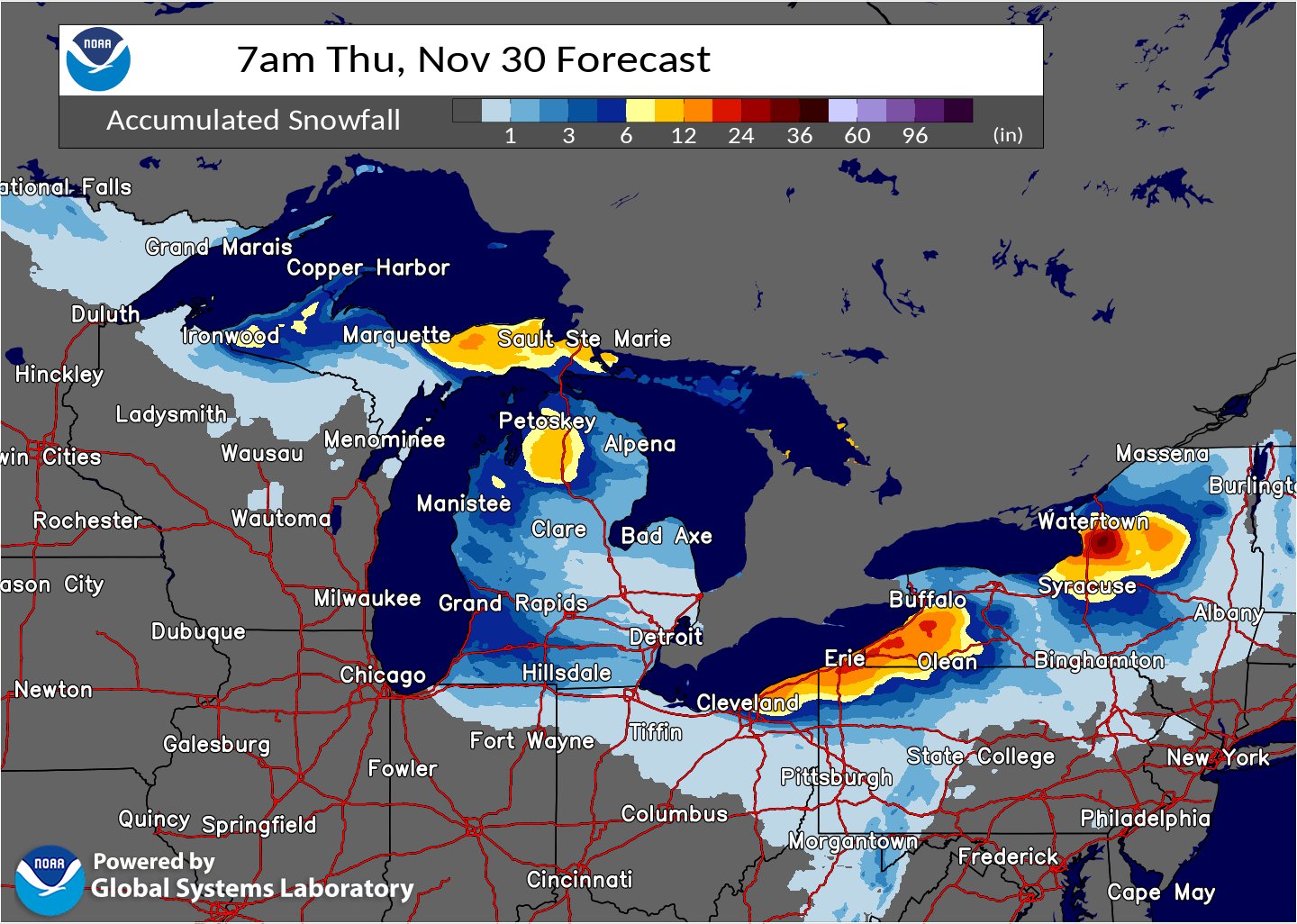
A significant Lake Effect snow storm should peak today, bringing snow total amounts to more than 3′ in some communities down-wind of the Great Lakes. With the heavy snow, Winter Weather Advisories and Lake Effect Snow Warnings are now in effect for many counties.
Embedded shortwaves in northwesterly cyclonic flow rounding a deep upper-level low over Canada will continue to produce snow downwind of the Great Lakes today, particularly Lakes Erie and Ontario. Here, additional forecast snow totals of 8-16″, with locally higher amounts, are expected through Wednesday morning, bringing storm total snowfall well above 2 feet for some locations. Some areas in upstate New York between Watertown and Syracuse could even see snow amounts to or beyond 3 feet. Heavy snow rates and gusty winds will make travel treacherous. Some lighter amounts of around 2-4″ will remain possible downwind of Lakes Superior and Michigan.
Some snow showers and squalls from the Great Lakes could travel great distances, bringing snow flurries to portions of eastern Pennsylvania, New Jersey, the New York City metro area, and even portions of northeastern Maryland and Delaware. While snow flurries are possible there far from the Great Lakes, accumulations of consequence aren’t expected.
The weather system responsible for the snow over the Great Lakes will also make portions of the Northeast and Mid Atlantic quite chilly in the coming days. Below average temperatures are expected for large parts of the East Coast and even portions of the South. Forecast highs Tuesday and Wednesday will be in the 20s and 30s for New England, 30s and 40s for the Mid-Atlantic, 40s and 50s for the Carolinas, and 50s and 60s from southern Texas along the Gulf Coast into the Southeast and all but south Florida. The coldest morning lows of the season so far are expected from the Mid-Atlantic through the Southeast Wednesday morning, with widespread 20s forecast. Temperatures may dip to near or below freezing as far south as the Florida Panhandle/north Peninsula northeastward through coastal South Carolina. With cold air expected to make its way into the southeast, A Freeze Watch has been issued for parts of the region as these temperatures may damage and kill sensitive crops and vegetation.
