Over the past few years we have heard the term “polar vortex” become part of the media’s vocabulary. What the public may not know about is the term SSW, which stands for sudden stratospheric warming, and the role it plays in shoving the polar vortex southward affecting the weather in our own backyard.
Dr. Judah Cohen is the Director of Seasonal Forecasting at AER (Atmospheric and Environmental Research) which is a division of Verisk Analytics and also a Research Affiliate at MIT’s Parsons Lab. He received a Ph.D. from Columbia University and was also a post-doc at the NASA Goddard Institute for Space Studies. “SSWs are a spike in the temperatures in the stratosphere over the Arctic. They can occur anytime from late November through March. They can displace or split the polar vortex.” Dr. Cohen continued, “When SSWs occur, they begin weakening the polar vortex and if it splits or displaces, they can send the coldest air in the northern hemisphere southward.”
If you are a fan of cold weather in the continental United States, you want a weakened polar vortex that has been shoved southward. A strong polar vortex is stagnant and is found over the North Pole and it simply will not move off the Pole. It thus keeps arctic air locked near the Pole.
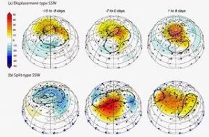
When a SSW occurs, it begins to erode the strength of the polar vortex. If the SSW is strong enough, it can weaken the polar vortex enough that it will move off the Pole. Dr. Cohen explained , “At this point, the polar vortex can split into two separate polar vortices, one which moves over North America and the other sets up over the Eurasian continent. Or it can hold together and become one, displaced polar vortex which heads south to over North America or Eurasia.”
SSWs can be predicted a week or two in advance. Once the SSW begins it will take about 14 days for the polar vortex to be moved off the Pole. According to Dr. Cohen, “The stronger the SSW, the more likely that the polar vortex can be moved off the Pole. There is also an immediate reaction of the atmosphere to the SSW near the Pole but it is generally short-lived and insignificant in the long run.”
Even though the polar vortex is now weakened, it still contains very cold, Arctic air. As it is pushed south, it brings this air with it. The eastern U.S. will see its coldest air of the season when the polar vortex is found just north of the Great Lakes and northwest winds from the Arctic region ushers in frigid temperatures. This is especially true if it is later in the winter season and the whole path of these winds is over frozen lakes or snow covered land.
Dr. Cohen continued, “When the polar vortex is weak and heads south, it can set up an amplified jet stream pattern with large dips and ridges in the jet stream. This is a setup for a very stormy pattern if you are located near one of these dips. However, if you are under one of the ridges, your region can experience unusually warm and dry weather. So, a SSW and a displacement of the polar vortex does not always mean Arctic temperatures for your locale.”
Also, whether the polar vortex is split into two separate vortices or holds together as one is important. Dr. Cohen explained, “There is evidence that a single polar vortex brings a higher likelihood of extreme Arctic outbreaks for the eastern U.S. like seen in January 1985. A split of the original polar vortex into two vortices is more often associated with blockbuster snowstorms …such as Boston saw in January and February of 2015.”