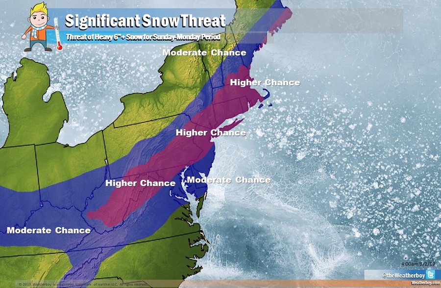
A significant winter storm threat looms for Monday near the I-95 corridor, bringing the threat of 6″+ of snow to an area that hasn’t seen much snow since December. With the threat of heavy snow, the National Weather Service has already started issuing Winter Storm Watches for portions of the northeast ahead of it.
A closed low centered around Hudson Bay Canada will send strong short wave energy southeast and eastward through the middle of next week, allowing the entire associated upper-level trough to amplify eastward, resulting in much colder air into the East. Such a pattern is expected to produce an expansive but quick moving storm that runs across our area later Sunday into early Monday ahead of the large trough amplifying eastward. Unlike the storms before it, this system has the potential of producing significant snow accumulations along and just west of I-95. Due to the threat of heavy snow for later Sunday into Monday, the National Weather Service has issued Winter Storm Watches for areas mainly west of I-95.
Who will get snow and how much will depend on the storm track. A closed low centered in the vicinity of Hudson Bay Canada will amplify eastward on its southern flank. Meanwhile, some lead short wave energy will assist with surface low development with its track nearly just south and east of the central Mid Atlantic Sunday night into early Monday. Today’s storm system will help set the stage for where this next system will travel. Early morning computer forecast guidance today suggests a more southeasterly track which would pull enough cold air down to produce heavy snow to the I-95 corridor and perhaps below it. With today’s storm getting a bit stronger east of New England, the mid level divergence in the height fields lessens and pushes more zonal thus keeping the southern short wave farther south. It appears the ingredients will come together on Sunday night, producing the most snow wherever it materializes.
On Monday, snow will taper off from southwest to northeast. Before everything is done, 6″ or more of snow could fall in portions of the Mid Atlantic and Northeast. The best chance for 6″+ right now is along and to the north of the I-95 corridor. Shifts south or north may occur and areas somewhat north and south of the I-95 corridor could see much more or less snow depending on the exact track. Once today’s storm exits and fresh atmospheric data is sampled, a better idea of who will get how much snow should be known by this evening.
The wintry pattern also looks to continue beyond Monday’s storm; forecast guidance suggests more snowstorm threats in the general same area around March 7 and 11.
