A significant winter storm will blast a large part of the eastern United States with heavy snow, heavy rain, potentially damaging wind gusts, and even storm surge / coastal flooding. And as if conditions weren’t messy enough, a considerable area that sees snow will see it change over to freezing rain, sleet, and/or plain rain before the storm exits. And while this storm is forecast to exit the northeast by Monday night, it looks like another winter storm is waiting in the pipeline –and that follow-up system could bring more substantial snowfall to the I-95 corridor and coastal plain.
While Wind Chill Advisories and Warnings are up for the northeast for tonight into tomorrow, a powerful storm coming out of the southeast will help surge milder air influenced by mild ocean temperatures from the Atlantic up the coastal plain on Sunday into Monday. While snow will fall heavy at times inland, the snow will change over to a wintry mix or plain rain, with more ice expected near the changeover line, and more plain rain expected at the coast.
While Washington, DC, Philadelphia, New York City, and Boston are all forecast to start as snow, precipitation should change over to plain rain during the height of the storm.
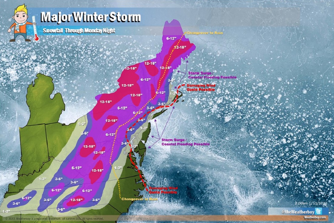
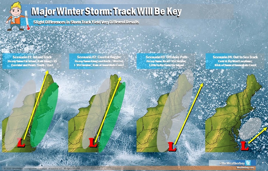
The changeover location is due to the current forecast storm track. At this time, it appears the storm will track very close to the I-95 corridor. This keeps heavy snow over interior New England down through central Pennsylvania and the spine of the Appalachian Mountains. This also brings milder air up into the coastal plain to the area around and just inland of the I-95 corridor.

Should the track of the storm actually be more east than where it is currently forecast to be, heavy snow and less rain would fall around the I-95 corridor.
More than a foot of snow is expected to fall over western North Carolina and Virginia, portions of West Virginia, central Pennsylvania, western and central upstate New York, and the higher terrain of Massachusetts, Vermont, and New Hampshire. Around a foot of snow could also fall in Maine before a messy change over to freezing rain, sleet, or plain rain there.
As the storm intensifies, there could be an area of damaging winds. While it is early to pin-down where those damaging winds could be, right now the best odds favor coastal North Carolina, Virginia, and Maryland, Delaware, New Jersey, Long Island, and extreme southeastern New England. The strongest winds would be at the immediate coast. Inland, winds could gust 30-45 mph; at the shore, gusts of 40 – 60 mph could be possible depending on just how deep this storm becomes.
Strong winds from a growing storm system could also set the stage for significant coastal flooding around Delaware beaches, the Jersey Shore, around Long Island, and coastal New England. The extent of flooding will be dependent on the storm’s track and wind field, timing of tides, and speed of the storm.
As the storm approaches, the National Weather Service could issue wind and coastal flood advisories as those high-risk areas are identified as more data is captured and digested by meteorologists and the computers they use for this storm.
While the storm will exit the northeast U.S. by Monday night, significantly colder air will arrive later next week. That cold air may come with another winter storm. With more cold air to work with, places along the I-95 corridor seeing mainly rain from this storm could see primarily snow from the next one.
But for now, this major winter storm will swing through the eastern United States over the next several days. An area of low pressure should form around Arkansas tomorrow, bringing heavy rain, strong storms, and mountain snow to the southeast on Sunday. Later on Sunday the storm will advance up the east coast, bringing snow to the I-95 cities late Sunday night before changing to plain rain by midnight / early morning Monday. The heaviest snow will fall from Sunday night through Monday afternoon in the northeast, with only light snow showers or flurries lingering over northern Maine by late Monday night / midnight Tuesday morning.