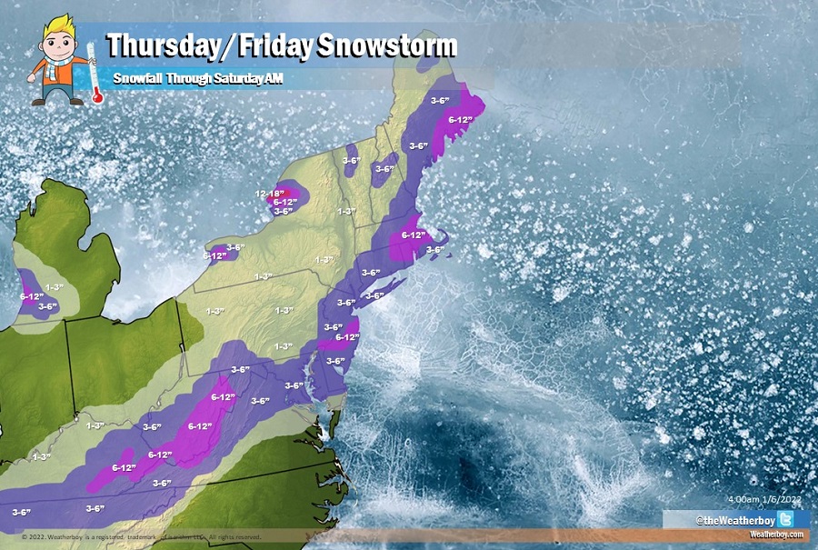
A sizeable snowstorm is forecast to bring plowable accumulations across a wide area, with the winter event kicking off today and lasting through Friday. The heaviest snow will fall on Friday near the I-95 corridor in New Jersey and southeastern New England, while winds will help kick-off significant lake effect snows in portions of Michigan and New York later Friday. While a widespread 1-3″ and 3-6″ snowfall is expected, some areas in the east will see 6-8″ and perhaps up to 10″ of snow while places like Watertown see upwards of 18″ and Buffalo will see upwards of 12″ of snow due to expected lake effect bands there.
Low pressure moving across the Southeast states today will emerge off the Mid-Atlantic coast tonight then move northeastward to off the New England coast during Friday, setting the stage for the winter storm. Precipitation will spread from Tennessee and Kentucky north and east into West Virginia and Virginia. As the storm takes shape early Friday, more snow will break out across New Jersey, New York, and southeastern New England.
Higher terrain will help produce more snow over eastern Kentucky and eastern West Virginia, where 6-10″ of snow is expected.
The I-95 cities of Washington, DC, Philadelphia, PA, and New York City, NY should all see around 3-6″ of snow by the time the snow wraps up by mid-morning Friday.
Heavier pockets of snow are expected to fall in mesoscale bands that are forecast to form over portions of central New Jersey, northern Rhode Island, northeastern Connecticut, and east-central Massachusetts. In the Garden State, 6-8″ with isolated amounts to 10″ are possible; near and to the south and west of the Boston metro area, 6-12″ amounts are forecast. 6-12″ is also expected over eastern Maine where snow should wrap up by later Friday afternoon.
In these mesoscale bands, narrow bands of heavier snowfall rates will set-up, producing snowfall amounts as great as 2″/hour. They won’t last very long, nor will the storm as a whole; because the storm is moving quickly to the north and east, the accumulation potential won’t be as high as a slower moving system. However, in areas where mesoscale bands form, areas just north and west of them will be “robbed” of precipitation. As such, expect several inches less snow, especially just north and west, of where these bands finally set-up.
Within the mesoscale bands, there is a slight risk of thunder. The National Weather Service reminds people: “when thunder roars, head indoors.” Lightning can kill even in the winter with falling snow; if thunder is close enough to be heard, lightning is close enough to kill.
Snow will quickly wrap up from southwest to northeast as cold, dry northwest winds flow over the northeast. Winds could gust as high as 25-35 mph in the northeast as the storm exits and the snow stops; this could create some blowing and drifting of fallen snow.

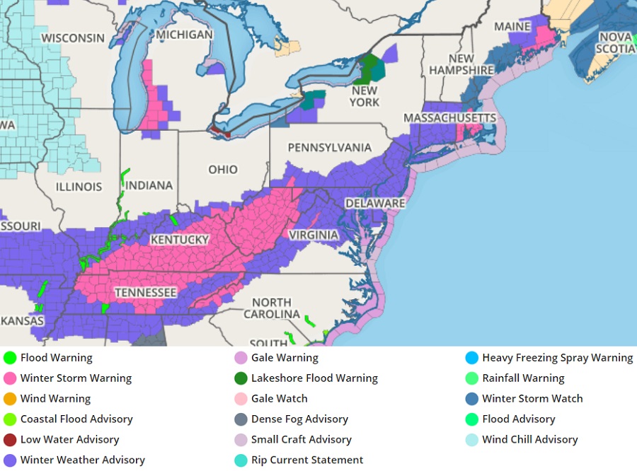
With snow on the way, the National Weather Service has issued a variety of winter watches and warnings for the eastern U.S.. Winter Storm Warnings have been issued for parts of Tennessee, Kentucky, West Virginia, North Carolina, Virginia, Rhode Island, Maine, and Massachusetts. Winter Storm Watches have been issued for portions of Maine, New Hampshire, and Massachusetts too. A very large area of Winter Weather Advisories are up elsewhere from Missouri and Arkansas east into Delaware, Maryland, New Jersey, and Virginia and up into New York and Connecticut.