• Skip to primary navigation
  • Skip to main content
  • Skip to primary sidebar

Weatherboy

Weatherboy Weather News, Maps, RADAR, Satellite, and Forecasts.

  • Local
  • Earth Science News
  • RADAR
  • Current Warnings
  • Satellite
  • Current Maps
  • Forecast Maps
  • Video

Sleet, Freezing Rain Ice Storm Impacts Portion of Mid Atlantic

by Weatherboy Team Meteorologist - February 13, 2021

The purple circled area, which stretches north and east from southern Virginia through eastern Maryland, all of Delaware, southeastern Pennsylvania, and southern New Jersey reflects where the greatest threat of icy weather is today. Image: NWS


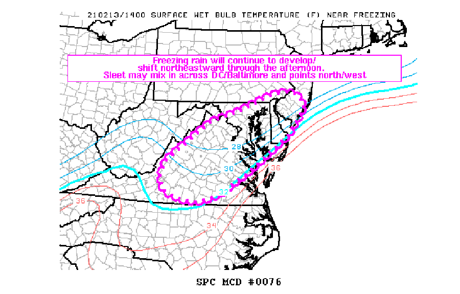
An ice storm consisting of sleet and freezing rain continues to impact portions of the Mid Atlantic today. The National Weather Service’s Storm Prediction Center (SPC) as issued a Mesoscale Discussion about an area of concern involving this storm from Virginia to New Jersey.

“Areas of freezing rain and occasional sleet will impact much of the Mid-Atlantic through early afternoon,” the SPC writes.  “A broad area of ascent/isentropic lift atop a shallow cold airmass continues to contribute to widespread freezing rain at this time. The freezing rain is reportedly mixing with sleet at times across the DC / Baltimore, MD areas, though a transition to more freezing rain should occur in that area over time as models indicate warm advection…”


This diagram shows how the thickness of cold or mild air above the surface helps determine the precipitation type at the surface. Image: NWS

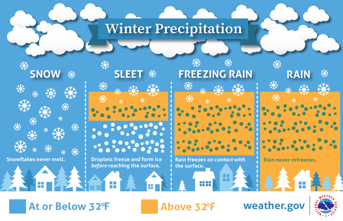
Precipitation types are based on the thermal profile of the atmosphere from the ground to the tops of clouds where precipitation first falls. When that vertical distance is completely below the freezing mark, snow falls. When there’s a layer of milder air for the precipitation to fall through, precipitation that starts as snow melts but re-freezes into an ice pellet, which hits the ground as sleet.  But when only the surface or the area immediately above is it frozen, the precipitation only re-freezes upon contact, leading to an icy glaze.


The SPC says, “Precipitation rates may approach 0.05 inch/hour at times beneath heavier precipitation bands. The general regime should persist through early afternoon, with a general northeastward expansion of the precipitation shield toward Delaware / southern New Jersey and the Philadelphia area over the next couple hours or so.”


The National Weather Service wants people prepared for an ice storm before it occurs. Image: NWS

Ice is extremely difficult to walk or drive in, especially on untreated surfaces. It is recommended that people stay put until the threat of ice has passed and outdoor conditions improve. It is nearly impossible to get any traction on untreated surfaces and even vehicles with four wheel drive can slide uncontrollably on roads covered with only a light glaze of ice.

Primary Sidebar

Sponsored Ad

Search

Latest News

  • Another Stronger Quake Rattles Ohio, Second in Two Days
  • Tropical Storm Philippe Forms in the Atlantic
  • Flood, Tornado Threats Persist After Landfall of Ophelia
  • Storm Surge Likely from South Carolina to New Jersey as Ophelia Makes Landfall
  • Tropical Storm Ophelia Continues to Gain Strength
  • Earthquake Rattles Northeast Ohio
  • Mid Atlantic Braces for Impacts from Ophelia: Tropical Storm Force Winds, Flooding Rains, Tornadoes, Life Threatening Storm Surge
  • North Carolina to New Jersey on Alert as Coastal Storm Takes Shape
About | Careers | Contact | Contests
Terms | Privacy | Ad Choices
Weatherboy is a (R) Registered Trademark of isarithm LLC, All Rights Reserved.
All content herein is Copyright by Isarithm LLC 1997-2022