A series of storms will put down considerable snow cover in the Northeast, but the most significant storm of the bunch may arrive on New Year’s Eve before 2018 arrives. And if the European ECMWF global forecast model is correct, some of the snow will be very deep, with more than a foot accumulation in total possible between now and New Year’s Eve for places like Philadelphia, New York City, and Hartford. Some locations may see 2 or more feet of snow, especially over interior New England, as these storms wrap up in the coming days -if the ECMWF is correct.
There remains significant run-to-run variability among the global forecast models. The two biggest players, the American GFS and the European ECMWF, have been at odds with each other how to deal with an active storm track and a cold pool of air entering the continental United States from Canada; they’ve been in significant disagreement for the period stretching from Christmas to New Years for the last few days. Meteorologists in the private and public sector use these models to help create weather forecasts; when the models disagree with each other, meteorologists’ forecast confidence drops. When individual runs vary wildly from prior runs, that confidence drops further.
While confidence remains low for the forecast from Christmas Eve to New Years Eve, it is slowly increasing as the models are being slightly more consistent with their outputs. However, there are still differences.
The latest American GFS brings a few storm systems from today through New Years Eve in the Northeast. The first is today, which will bring light snow to central and northern New England. The GFS then brings in a warmer, more wet system in for the 23rd and 24th, but wraps snow on the back end of that storm in New England as it exits the region. The GFS now develops an area of low pressure close enough to the coast on Christmas Day to produce snow for places like Philadelphia, New York City, and Boston. However, most accumulating snow would be in New England again. After a lull, the GFS brings up a final storm of the year up the east coast, bringing snow to the I-95 corridor. When all is said and done, the GFS has less snowfall accumulations than its more robust ECMWF peer.
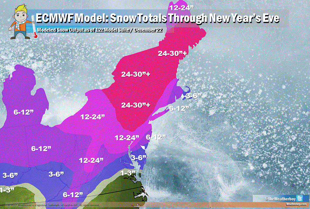
The latest European ECMWF brings a lot of snow to the northeast over the next 9 days. Like the GFS, it produces measurable snow over central and northern New England today into tonight. Like the GFS, another system swings through for Christmas. However, it is a warmer solution than the GFS, which translates to more wet than white for places like New York City and south. Nevertheless, it produces decent snowfall over New England. Afte r a lull until the 30th, the ECMWF then spawns a significant coastal snowstorm off the Mid Atlantic, which would put down heavy snow along the I-95 corridor from central Virginia north to Maine. This storm alone would produce heavy snow amounts, building a base in the Mid Atlantic and adding to the snowpack of New England.
