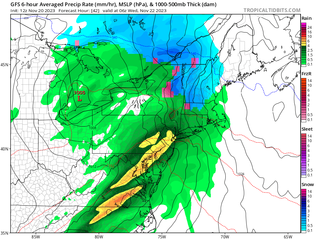
Unfortunately for those planning to travel around the northeast this Thanksgiving holiday, snow, rain, and severe thunderstorms could make travel by air or by car problematic for many. A severe weather system located tonight and tomorrow across the Lower Mississippi Valley Central Gulf coastal regions will be shifting east on Wednesday, impacting the Mid Atlantic and Northeast with a mixed bag of precipitation. In addition to widespread heavy rain east of the Mississippi over the next two days, a period of wintry weather possible from the Central Appalachians into portions of the Northeast and Northern New England by Wednesday.
Two systems are expected to impact the northeast: one on Wednesday ahead of the Thanksgiving holiday, and the other on Sunday as people head home from the holidays.
A developing area of low pressure across the Central Plains later today will be pushing east northeastward over the next two days, producing potential high impacts during the upcoming busy pre-Thanksgiving Day travel period for large portions of the country from the Mississippi River eastward. Precipitation associated with this storm is already fairly well defined late this afternoon across portions of the Central to Southern Plains toward the Middle to Lower Mississippi Valley. This precipitation area will remain well defined tonight with increasing thunderstorm potential across the Lower Mississippi Valley and Central Gulf Coastal region tonight into Tuesday. Along with the heavy rain potential, severe weather is possible across these areas with high winds, hail and tornadoes possible. To the north of the area of severe weather threat, widespread moderate to heavy rains are likely to the east of the Mississippi river, across the Tennessee and Ohio Valleys, Appalachians, Southeast, Mid Atlantic and into the Northeast.
Nearly all of these regions have had much below average precipitation over the past several weeks, with areas from the Lower Mississippi Valley into the Tennessee Valley in Severe to Exceptional drought conditions. Given these recent dry conditions, stream flows and soil moisture are below average, which should decrease the threat of flash floods. However, isolated flash flooding still possible given the heavy rainfall threat, especially across urban areas.
Nearly all of the precipitation to the east of the Mississippi River with this developing storm will be in the form of rain. The exceptions to this will be from the Central Appalachians into portions of the interior Northeast where a period of sleet and freezing rain is possible at the onset of the precipitation Tuesday morning before changing over to rain.
A period of accumulating snows are also possible across northern New York State into Northern New England Tuesday night into Wednesday before this precipitation also changes over to rain.
Much colder temperatures expected across the Northern Plains beginning late Wednesday into Thanksgiving as a strong cold front pushes southward out of central Canada.
As that cold front reaches to the coast, it is possible a more substantial coastal storm will form, producing heavy snow and rain over portions of the northeast. It is too soon to say with certainty where the rain/snow line will set-up for this next system for Sunday/Monday, but the best odds for accumulating heavy snow are over northern New England well away from the heavily populated I-95 corridor at the coast.