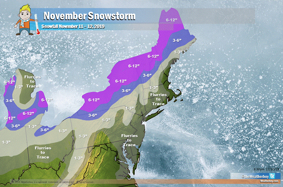
The National Weather Service has begun to issue Winter Storm Watches and Warnings for an early-season snowstorm that is expected to dump as much as 6-12″ of snow across portions of the northeast. A strengthening low pressure system is forecast to move through the northeast from late Monday through early Tuesday, bringing rain or a wintry mix changing to snow across a wide area. Behind the storm, near-record cold is expected midweek as Lake Effect snow showers stream into the northeast.
A variety of ingredients are coming together to produce the significant accumulating snow. A weak surface boundary oriented from southeastern Quebec back into the Ohio Valley will drag eastward across the region tonight and stall out as it gets cut off from the flow. A weak upper wave embedded within the westerly flow will lift to the east-northeast through the easter Great Lakes tonight and interact with the surface front to trigger some rain showers initially, but then mix with and change to snow by Monday morning in upstate New York. The change-over will occur from higher elevations down to the valley locations as the colder air descends upon the area. This boundary area will remain nearly stationary across southern New York / northern Pennsylvania on Monday morning, laying down the track for the incoming low pressure system over the central Appalachian Mountains. The surface low is expected to deepen as it moves to the northeast across eastern Pennsylvania into northern New England Monday afternoon through Tuesday morning. At the same time, the parent upper low to the west will dig sharply through the Great Lakes as a strong upper level jet rounds the bottom of the trough and supplies enough dynamics to make this a very efficient winter storm across interior sections of New England.
While some mixed precipitation is possible over the Chemung River Valley and the Catskills, it should change over to plain snow by Tuesday. North of there, though, heavy snow is likely. The potential for heavy snow is mostly likely across the northern Finger Lakes into the western Mohawk Valley and southern Tug Hill plateau Monday afternoon through Monday night when the system wraps up and a period of strong forcing becomes apparent within a deformation zone in the northwest quadrant of the system. A band of heavy snow is expected to set up along the lake plain south of Lake Ontario and then swing through north-central New York Monday evening and Monday night. During the overnight hours, snowfall rates could reach as high 1″/hour at times. On Tuesday, as the system pulls out of the area quickly in the morning, the cold Canadian air mass will blast into the area and allow lake effect snow showers to continue se of Lake Ontario most of the day. The boundary layer will likely deepen through the day and allow for too much instability to organize the snow into a singular band. The snow showers will likely be more cellular in nature, generating an additional inch or so in some locations.
To the south, in the I-95 corridor from Baltimore to New York City, mainly rain will fall; the cold air will arrive after much of the precipitation exits the region. However, even there and into portions of southern New Jersey, Delaware, and eastern Maryland and Virginia, some flurries could happen at the tail end of the storm, with a light dusting of snow possible in isolated areas.
While a dusting is possible in the south side of this system, a large area of 3-6″ snowfall is expected, with 6-12″ expected on the northern side of the system. With these snowfall amounts, this will be the most widespread significant snowfall yet of the young fall/winter snow season. With this being the first snow for many this season, people are urged to exercise extreme caution when being out and about on area roads and sidewalks.
As the snow exits from west to east on Tuesday, cold air will return, with below normal temperatures likely for a large part of the eastern U.S. for the balance of the week.