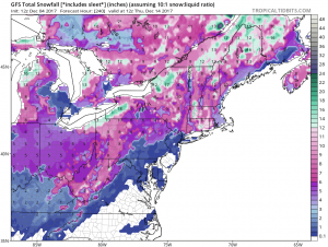
The weather pattern is evolving into one that better supports snowstorms in the northeastern United States; now, what needs to be seen is whether or not key ingredients will come together within this favorable pattern to produce heavy snow. It is still too soon to know with certainty if those ingredients would come together; a better idea will be known by Wednesday as more data is ingested into forecast models and meteorologists have an opportunity to review fresh insights in the atmospheric profile.
Overnight model guidance is a bit different from daytime guidance. The American GFS model suggested a heavy swath of snow would fall from Maryland and Delaware north through New Jersey, southeastern New York, and southeastern New England. The European ECMWF wasn’t as bullish with the snow, calling for lighter amounts. But afternoon runs of both models have flipped a bit, with the GFS suggesting much lighter amounts near the Mid Atlantic while the ECMWF suggests heavier amounts where the overnight GFS originally had them. Until there is better run to run consistency with each model and some consistency or alignment between those two major global forecast models, meteorologists will have a low confidence in the winter storm forecast.
While locations and amounts of snow are questionable, much colder air is a near certainty for most of the Mid Atlantic and Northeast for the upcoming weekend. A deep trough will dig into the Great Lakes and Ohio Valley, sending Arctic high pressure east. This trough will bring a much colder air mass to the region, resulting in highs only in the upper 30s to low 40s to places like Philadelphia and New York City Thursday through Saturday.
With this trough digging into the Eastern US, several strong shortwaves will dive into the base of the trough. A surface low should form off the southeastern US coast on Friday morning, tracking along the coast later Friday into Friday night. It is this system and its evolution that will help determine who will get wintry precipitation next weekend. Beyond this initial coastal low, several shortwaves will pass through the northeast over the weekend, touching off a period of light precipitation from the weekend into the early part of next week.