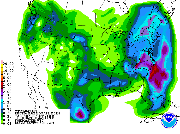
A series of low pressure systems is forecast to bring soaking rains to the eastern United States this week, adding to the chilly and wet weather woes that have plagued the region for the last several weeks. An occluding low pressure system will continue moving across the southern Appalachians early today before slowing moving into the Carolinas by the afternoon. This will bring soaking rains to the southeast. In the Mid Atlantic, a south-southwest flow aloft will lead to increasing moisture through the day. A few short wave vorticity impulses will lift across the Mid Atlantic through the day too. Rain chances will increase from south to north . With little to no instability forecast, thunderstorms are not expected at this time. However, winds will become gusty with some gusts reaching 20 to 30mph at times. The greatest winds will be along the coastal plain.
With rain and wind expected, conditions will feel raw. Rain will be at heavy at times too, with some flooding problems possible tonight. The heavy rain area will likely not spread north of the southern Mid Atlantic, sparing the New York City metro area and southern New England from the heaviest rain.
For the end of the week there remains some uncertainty in how two low pressure systems, one lifting out of the southeast and becoming a coastal low and one digging out of the north central US, will interact and what the impact will be for the eastern US. The latest computer forecast guidance suggests that the Northeast will see a brief chance of rain on the back side of the coastal low on Friday night or Saturday. There also appears to be a limited impact from the cold front moving in from the west.