• Skip to primary navigation
  • Skip to main content
  • Skip to primary sidebar

Weatherboy

Weatherboy Weather News, Maps, RADAR, Satellite, and Forecasts.

  • Local
  • Earth Science News
  • RADAR
  • Current Warnings
  • Satellite
  • Current Maps
  • Forecast Maps
  • Video

Soaking Forecast Prompts Widespread Flood Alerts

by Weatherboy Team Meteorologist - December 19, 2018

A large storm pushing into the northeast has prompted the National Weather Service to issue many products ahead of the storm.  Image: weatherboy.com
A large storm pushing into the northeast has prompted the National Weather Service to issue many products ahead of the storm. Image: weatherboy.com


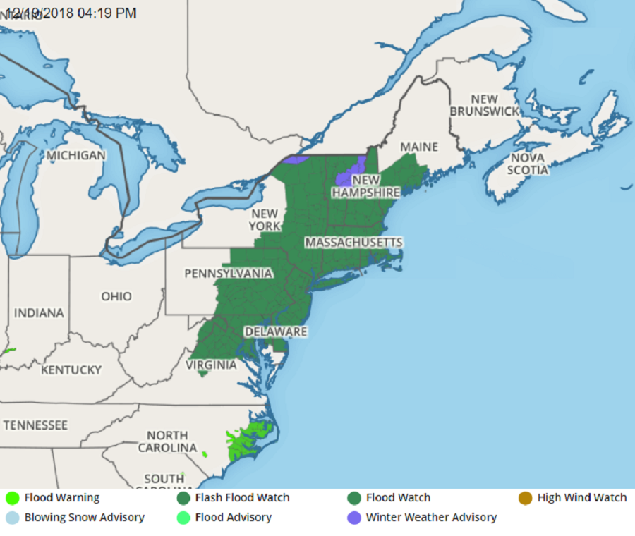
A large, soaking rainstorm will bring a windswept deluge to portions of the eastern United States over the next few days, prompting the issuance of widespread Flood Watches. In addition to the Flood Watches that are up for all of New Jersey, Delaware, Connecticut, Rhode Island, and Massachusetts, along with portions of New York, Vermont, New Hampshire, Maine, Maryland, Pennsylvania, and Virginia, the National Weather Service has issued a Wind Advisory for much of the southern half of New Jersey and all of Delaware. Coastal Flooding could also be a problem; in addition to the freshwater flooding, the combination of heavy rain and increased tide levels during the times of high tide Thursday night through Friday morning will result in widespread moderate to locally major coastal flooding along the Atlantic, Delaware Bay, the tidal Delaware River, and the eastern shores of the Chesapeake Bay.


More than 2-3" of rain is possible in the eastern U.S. through Saturday.  Image: NWS
More than 2-3″ of rain is possible in the eastern U.S. through Saturday. Image: NWS

The different advisories up have different meanings. A Flood Watch means there is a potential for flooding based on current forecasts. A Wind Advisory means that very windy conditions are expected. Winds this strong can make driving difficult, especially for high profile vehicles. The National Weather Services encourages that people in the Wind Advisory area use extra caution and to secure outdoor objects; light-weight outdoor objects such as patio furniture and garbage cans blow about.


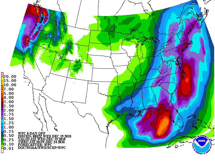
Winds and rain from this system can become quite severe. Late Thursday night through Friday morning, winds will become south 20 to 30 mph with gusts up to 50 mph. in the Wind Advisory area. At least 1.5-2.5″ of rain is likely in the Flood Watch area; some areas may see 3-4″ or more of rain, with the greatest amounts along and east of the I-95 corridor in the Mid Atlantic and Northeast.

Primary Sidebar

Sponsored Ad

Search

Latest News

  • USGS Keeping Four U.S. Volcanoes at Elevated Risk Alert Levels this Holiday Weekend
  • Tropical Storm Colin Weakens to Depression; Warnings Dropped
  • Tropical Storm Bonnie Enters the Pacific, On its Way to Become a Hurricane; Could Bring Moisture to Hawaii
  • Puerto Rico & the USVI Is Shaking this Holiday Weekend; More than 475 Earthquakes Strike the Region; No Tsunami Threat at this Time
  • Earthquakes Rattle Southern Missouri near New Madrid, Home of Violent 1811 Quake
  • Tropical Storm Colin Forms along South Carolina Coast; Warnings Issued for U.S. East Coast
  • Tropical Trouble Brewing Along U.S. East Coast?
  • Tropical Storm Bonnie Making Landfall; Will Cross into Pacific
About | Careers | Contact | Contests
Terms | Privacy | Ad Choices
Weatherboy is a (R) Registered Trademark of isarithm LLC, All Rights Reserved.
All content herein is Copyright by Isarithm LLC 1997-2022