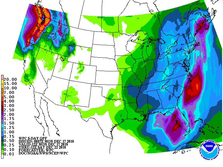
After a wet weekend, more heavy rain is on its way to the eastern U.S. Low pressure is forecast to develop in the south and march north and east, bringing soaking, potentially flooding rains, to the East Coast on Thursday and Friday.
On Thursday, the central U.S. trough is forecast to deepen with the southern-stream component intensifying rapidly. Surface cyclogenesis should begin in the Deep South during the day as the large-scale trough begins to develop a negative tilt. Downstream ridge amplification should allow temperatures to rise even further in the Mid-Atlantic, with highs 5 to 10 degrees above seasonal averages. With milder air surging north, precipitation from this system will fall mainly as rain.
The onset of the heaviest precipitation should be Thursday afternoon into Thursday night and Friday, with the heaviest rain expected from the Carolina coast north into the New York City metro area. A widespread one to two inches of rain is expected along much of the eastern U.S., but heavier rain is possible as a band of heavier convection forms from northern Florida up to the Mid Atlantic states Friday morning. In this band, 2-4″ or more of rain could fall.
With more heavy rain in the forecast combined with a long-term wet pattern and recent heavy rainfall, river and areal flooding could be an issue Thursday night into Friday, especially in portions of the Mid Atlantic.
As the storm moves north and east, a northwest flow on the upstream side of the system will
likely wrap around on the back side of the precipitation shield, producing some snow showers late Friday night and Saturday in interior portions of the northeast. With most of the precipitation falling on the warm side of the storm, any snow that falls will be light.
The departing low will also allow winds to increase out of the northwest and become gusty Saturday and Saturday night. With colder air arriving, the increasing winds will make Saturday night feel colder than it’s been recently in many locations across the Northeast and Mid Atlantic.
On Sunday, conditions will become fair, setting the stage for a fair and dry Christmas Eve and Christmas morning for much of the country east of the Mississippi River.
