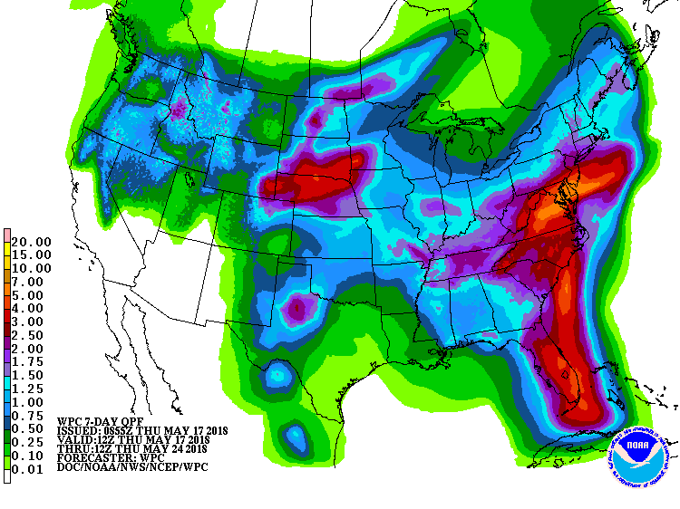
A very wet weather pattern will help an already soggy Eastern US become soaking wet. A few more days of unsettled weather can be expected across the Atlantic coast as tropical moisture from the Gulf of Mexico interacts with a stationary front. A few inches of rain is possible from now through the weekend, with even more rain likely in the new week next week.
A nearly stationary front will extend from the central Appalachians through the central Mid-Atlantic through Friday night, with a series of surface lows moving slowly along the front. A stronger low will move from the Tennessee Valley tonight into the Northeast by Sunday, allowing the front to lift north before slowly dissipating this weekend. A cold front will approach the Atlantic coast early next week before stalling to the south by midweek. With this atmospheric set-up, heavy rain will fall, with more than 4″ possible across portions of New Jersey, Florida, Delaware, Maryland, Virginia, and the Carolinas. Such heavy rain on already saturated soil could lead to flooding conditions.
Due to the flood threat, the National Weather Service has issued flood-related advisories for portions of Florida, Virginia, Delaware, New Jersey, Pennsylvania, Maryland, North and South Carolina, and West Virginia. People in these areas should avoid flood waters and remember it is never safe to travel through flood waters of any depth: turn around, don’t drown!