A spring-like severe weather event is expected to unfold this week and the National Weather Service and their Storms Prediction Center is getting the word out now to make sure people are prepared for severe thunderstorms and tornadoes that could form in the coming days. It is also possible severe weather would impact portions of the Mid Atlantic and Southeast by Friday.
A volatile weather situation should exist by Wednesday and Thursday over portions of the south-central and Gulf coast states. A strong shortwave trough is forecast to extend from the Four Corners southwest across the northern Baja Peninsula early on Wednesday. This shortwave is then expected to progress eastward throughout the day while also pivoting towards a more negative tilt as it moves through the southern Plains on Thursday morning. This system should then continue northeastward through the ArkLaTex/Ozark Plateau and the Mid Mississippi Valley.
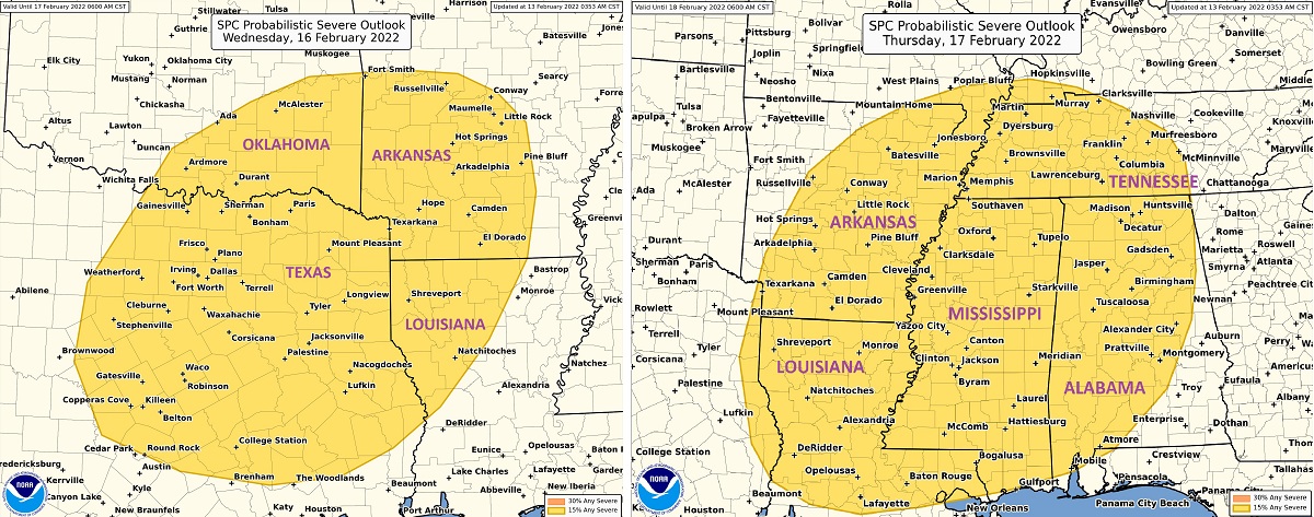
According to the National Weather Service’s Storm Prediction Center, a strong southerly low-level flow will precede this shortwave, contributing to strong moisture advection across the southern Plains, Lower Mississippi Valley, and Southeast. In addition to this moisture, and associated modest atmospheric buoyancy, strong deep-layer shear will be in place as the strong low-level southerly flow veers more southwesterly aloft.
This combination of vertical shear and buoyancy is expected to result in the development of severe storms. For now, it appears the focus of severe storms will be over eastern Texas, northwestern Louisiana, southeastern Oklahoma, and western Arkansas on Wednesday. On Thursday, this area of concern will shift east into portions of Mississippi, Alabama, and Tennessee.
While a surge of cold, continental air is anticipated in the wake of this shortwave, thereby extinguishing the threat of severe weather over the central states, there is a possibility there could be strong to severe storms, heavy rain, and possibly even damaging winds in portions of the Mid Atlantic and Southeast Coast on Friday before the cold air reaches the coast.
