While the calendar says we’re entering the first full weekend of Spring, it appears Old Man Winter is in no hurry to leave. Yet another winter storm will be pushing east, giving some upwards of 6-12″ of snow. However, unlike the last four major winter storms to strike the eastern United States, this one won’t transform into a nor’easter and won’t produce measurable snow in areas that saw recent heavy snow in the I-95 corridor.
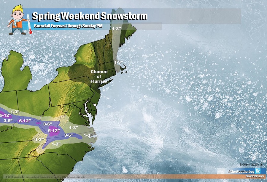
The storm system responsible for this significant accumulating snow will be racing from the Plains region, head south of the Great Lakes, and exit the East Coast along the southern Mid Atlantic Coast. Before the storm exits the east coast, 1-3″ is expected over much of northern North Carolina, southern and western Virginia, southern West Virginia, northern Kentucky, southern Ohio, and central Indiana. Within this area, a narrow band of 3-6″ will fall, with pockets of 6-12″ possible, with the highest snow amounts expected over southeastern West Virginia and adjacent areas in Virginia.
A non-related disturbance will also bring snow showers and snow flurries to portions of the northeast. With the exception of a narrow band where an inch or two of snow could accumulate, most snow in the northeastern US will not stick.
Once this storm system exits, high pressure will return, bringing dry and somewhat milder air to the eastern United States. Eyes will then turn to the next possible storm system, which could strike the East Coast as early as Thursday or as late as Easter Sunday. Either way, that next storm should be more wet than white with temperatures supporting primarily rain.
