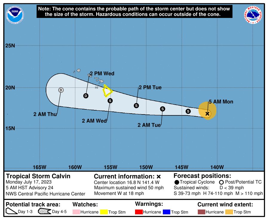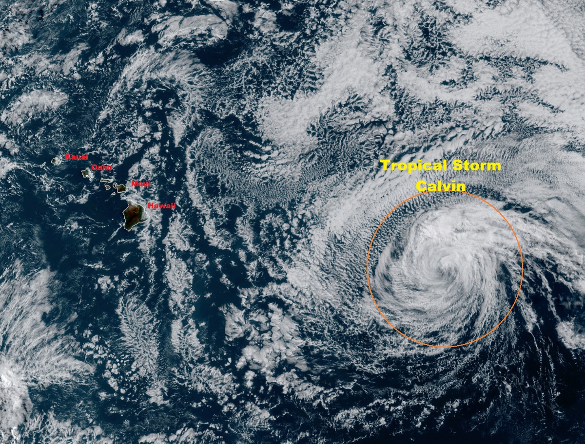
The Central Pacific Hurricane Center (CPHC) in Honolulu, Hawaii has issued a Tropical Storm Watch for the entire island of Hawaii, the largest island of the state also referred to as the Big Island; meteorologists there are warning residents to prepare for possible impacts which can include flooding rains, damaging winds, and even isolated tornadoes. A Tropical Storm Watch means that tropical storm conditions are possible within the watch area, in the case with the next 36 to 48 hours.
As of the latest advisory from the CPHC, Calvin was located about 920 miles east of Hilo on the Big Island and about 1,120 miles east-southeast of Honolulu on the island of Oahu. Maximum sustained winds were at 50 mph while the minimum central pressure was estimated to be 1000 mb or 29.53″. The storm is moving to the west at 18 mph.
Calvin is forecast to continue to weaken, but remain a tropical storm as its center moves over or near the southern part of the Big Island. The CPHC cautions people that impacts from Calvin can extend hundreds of miles out from the center of the storm. From Tuesday night into Wednesday, storm total amounts of 4-8″ are possible along windward (eastern) areas of the Big Island of Hawaii, with lower amounts of 1-4″ expected elsewhere in the state. While rain should wrap-up over the Big Island by Wednesday late afternoon or evening, lingering showers are possible over the rest of the state into Thursday. Rainfall on this magnitude over a short duration could lead to flash flood problems and mudslides. People are encouraged not to travel during the storm and to definitely not drive through flood waters.
Locally strong winds may begin as early as Tuesday evening across parts of the Big Island, with north winds shifting to the northeast and east as Calvin moves westward. Winds will primarily be northeasterly over the smaller islands, strongest Wednesday and Wednesday night. It is important to note that the mountainous terrain of the islands can produce localized areas of enhanced winds, even well away from the tropical cyclone center. Winds down-slope of the Saddle on Hawaii Island, including the Waikoloa region, could be especially strong. For now, the strongest storms will be on the northern side of the storm and will increase with elevation. Winds of 15-25 mph with gusts to 30-40 mph are possible in places like Hawaii Ocean View Estates, Naalehu, Kailua-Kona, Captain Cook, Milolii, and Pahala while winds of 30-40 mph with gusts to 55 mph are possible for Hilo, Pahoa, and Volcano. For Waimea, Hawi, Honokaa, Kawaihae, and Waikoloa, winds could reach 25-45 mph with gusts 50-70 mph.

Coastal impacts associated with Calvin will include rapidly building surf Tuesday night through Wednesday. Surf heights will reach High Surf Advisory levels for most windward coasts, potentially reaching High Surf Warning levels greater than 15 feet along east facing shores of the Big Island. Although peak surf heights on the Big Island will likely occur around low tide Wednesday morning, some minor overwash and erosion is possible for exposed low-lying coastal areas.
The Honolulu National Weather Service office also says conditions are somewhat favorable for tornadoes across much of the Big Island. Water spouts are possible at the coast.
For now, numerous types of weather hazards and impacts are possible, including wind damage and flooding rains.
The CPHC urges people across the Big Island to prepare for dangerous winds which could have possibly significant impacts across the Big Island. Potential impacts include some damage to roofing and siding materials, along with damage to porches, awnings, carports, and sheds. In the highest gusts, a few buildings could experience window, door, and garage door failures. Unsecured lightweight objects become dangerous projectiles; these should be secured or removed before the storm arrives. Winds of the magnitude forecast could snap or uproot several large trees, but with greater numbers in places where trees are shallow rooted. Several fences and roadway signs also blow over at these forecast speeds. Some roads may become impassable from large debris, and more within urban or heavily wooded places. A few bridges, causeways, and access routes may also become impassable. There will also be scattered power and communications outages, but more prevalent in areas with above ground lines. Wind related issues are forecast to be limited only to the Big Island of Hawaii.
The CPHC also wants people to prepare for dangerous rainfall flooding which could have possible significant impacts across mainly windward and southeastern portions of the Big Island. Potential impacts include the potential for moderate rainfall flooding which could prompt several evacuations and rescues, rivers and tributaries may quickly become swollen with swifter currents and overspill their banks in a few places, especially in usually vulnerable spots. Small streams, creeks, canals, arroyos, and ditches will overflow. In some cases, flood waters can enter some structures or weaken foundations. Several places may experience expanded areas of rapid inundation at underpasses, low-lying spots, and poor drainage areas. Some streets and parking lots take on moving water as storm drains and retention ponds overflow. Driving conditions will become hazardous, especially as roads and bridges close. The Big Island will see the most flooding impacts, but isolated flooding is also possible from Kauai to Maui.