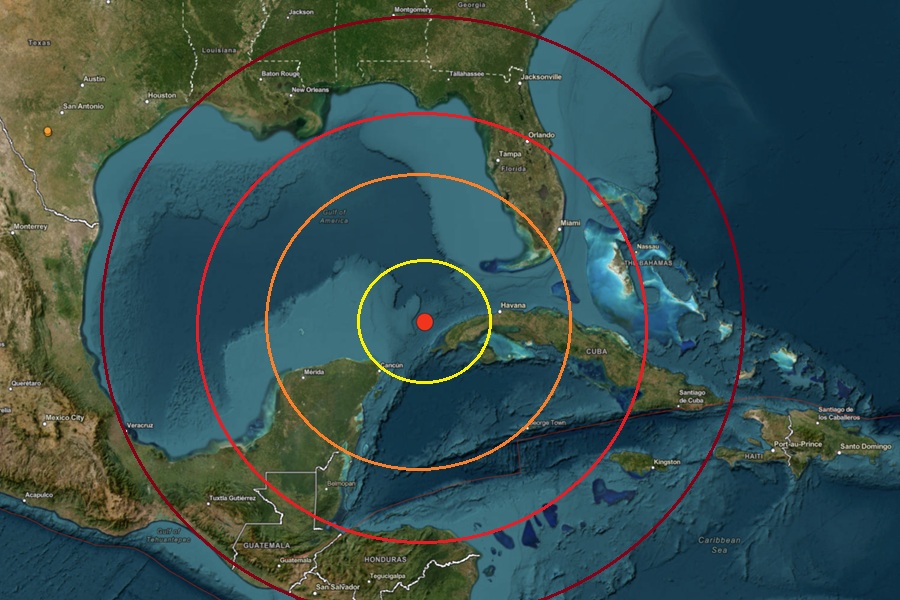
Moments ago a strong 6.1 magnitude earthquake struck along the Cuba Trench with thousands of people around Florida and elsewhere along the Gulf Coast reporting they felt it to USGS via their website reporting tool. The earthquake struck at 2:00 pm eastern time from a depth of 26 km about 104 km from Mantua on Cuba’s west coast. The earthquake was initially reported as a stronger 6.4 magnitude event but USGS subsequently re-evaluated it down to a still-strong 6.1.
The National Weather Service’s Pacific Tsunami Warning Center (PTWC), which is also responsible for issuing Tsunami Advisories and Warnings to the Gulf of America and U.S. East Coasts, issued a bulletin shortly after the earthquake. “Based on all available data, there is no significant tsunami threat from this earthquake,” the PTWC said. They added, “However, there is a very small possibility of tsunami waves along coasts located nearest the epicenter.”
“There is no tsunami danger for the U.S. east coast, the Gulf of America states, or the eastern coast of Canada,” wrote PTWC in an additional bulletin to address other areas exposed to tsunami threats.
As of press time, more than 3,600 people across much of Florida used the “Did you feel it?” online reporting tool at the USGS website to report feeling the earthquake.
USGS says there was no other earthquake activity within 155 miles of today’s earthquake over the last 3 weeks.
Tsunamis are giant waves caused by earthquakes or volcanic eruptions under the sea. Out in the depths of the ocean, tsunami waves do not dramatically increase in height. But as the waves travel towards land, they build up to higher and higher heights as the depth of the ocean decreases. The speed of tsunami waves depends on ocean depth rather than the distance from the source of the wave. Tsunami waves may travel as fast as jet planes over deep waters, only slowing down when reaching shallow waters. While tsunamis are often referred to as tidal waves, this name is discouraged by oceanographers because tides have little to do with these giant waves.
A tsunami is a series of waves not simply a single event. The time between wave crests can vary from 5 minutes to an hour. The hazard may persist for many hours or longer after the initial wave. Impacts can vary significantly from one section of coast to the next due to local bathymetry and the shape and elevation of the shoreline. Impacts can also vary depending upon the state of the tide at the time of the maximum tsunami waves.
While the Pacific is better known for tsunamis, tsunami can and does occur in the Atlantic basin too. As with the Pacific basin, earthquakes can trigger a tsunami threat for the U.S. East and Gulf coasts. According to USGS, submarine landslides can be one result of an Atlantic-based quake. An offshore earthquake with a magnitude 4.5 or greater can destabilize the continental shelf, causing massive underwater avalanches. These landslides displace large volumes of water and can generate significant, localized tsunamis. This was the case during the 1929 Grand Banks earthquake near Canada, which caused a destructive localized tsunami. Distant tectonic earthquakes can also create problems; massive earthquakes along faults further away in the Atlantic, such as the Azores-Gibraltar Transform Fault near Portugal or the Puerto Rico Trench in the Caribbean, are capable of generating tsunami waves that travel across the ocean. While the infamous 1755 Lisbon earthquake created a trans-Atlantic tsunami that was recorded on the East Coast, the height of the waves reaching the US mainland was relatively small but different earthquake intensities and locations can trigger very different results.
