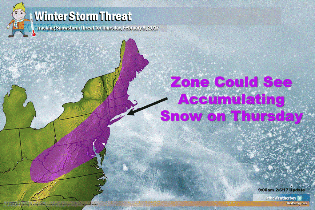
Odds are increasing for a Thursday snow threat for portions of the Mid Atlantic and Northeast. Six inches or more of snow may accumulate as ingredients come together for a snowstorm; however, big questions remain about those ingredients and where exactly they’ll come together.
An area of low pressure will track through the Great Lakes region, bringing rain and mild air far up the northeast US coast during the day on Tuesday. Rain will make it as far north as Quebec, Canada. Some freezing rain and snow is also possible across portions of New England, creating slick conditions there later Tuesday into Wednesday. Temperatures are forecast to be very mild if not outright warm over portions of the southern Mid Atlantic as a strong southerly flow sets-up ahead of this low pressure system.
As this low pressure system departs the United States to eastern Canada, significantly colder air will flow down into the Mid Atlantic and Northeast from central Canada. This key ingredient -cold air- will help set the stage for a winter storm on Thursday even after unusual warmth on Wednesday.
A new area of low pressure will form at the surface near the Appalachian Mountains and move east, bringing precipitation to the Mid Atlantic and the Northeast. As this precipitation moves into the cold air, snow will form.
Many storms in recent weeks have quickly departed the eastern US, not getting much time to intensify or put down much in the way of precipitation. However, unlike those previous storms, a bit of an atmospheric “traffic jam” is setting-up over the Atlantic Ocean which will help slow down this Thursday winter storm threat. While there is no complete blocking pattern, the pattern will help slow things down just enough to make the weather interesting.
While interesting, the unfolding weather scenario is very complex with many details yet to be ironed out. While a storm is likely, where it goes, how much cold air it’ll tap into, and how long it will linger remain open questions.
Our map above depicts an area that -could- see snow from Thursday’s storm. Storm track and the rain/snow line will play a major role in who see’s heavy snow or any snow. At this time, it appears the best chance of accumulating snow is over central New Jersey and the New York City metropolitan area. South of there, the rain/snow line may creep north just far enough to keep snow away or snow totals low. Further north and west of the New York City area, if this storm hugs the coast or heads further east than east north east, little to no snow may fall there with most precipitation confined to the coast. The exact storm track will also determine whether southeastern New England sees snow from this storm; the more east-north-east the storm moves rather than north-east, the more likely snow will remain closer to the New York City metro area and not expand north towards Boston. If the system does jog north and east more than expected, significant snow would slide into much of southeastern New England.
More atmospheric readings are needed over the next 24 hours to help forecasters determine who will get precipitation and what form that precipitation will fall in. Until the forecast is refined, those in the purple zone should prepare for the possibility of wintry conditions on Thursday.