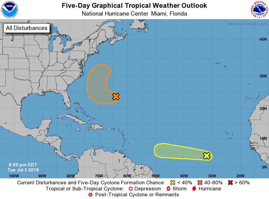
In their latest five day outlook today, the National Hurricane Center shared that they are keeping a close eye on two disturbances in the Atlantic Hurricane Basin not far from the U.S. East Coast. They’re giving the one that’s closer to the U.S. a 50-50 shot of becoming a tropical cyclone this week, while they don’t expect the second system, near the Cabo Verde Islands, to form into much.
According to the National Hurricane Center (NHC), an area of disturbed weather located a few hundred miles southeast of Bermuda has changed little today. However, environmental conditions are gradually forecast to become more conducive for the development of a low pressure system by late this week when the disturbance is expected to be south or southwest of Bermuda. The system is forecast to move generally northward over the weekend and begin interacting with a frontal system on Sunday, which would limit both any additional development and an approach to the U.S. East Coast. The NHC believes there’s a low 20% chance of formation here over the next 48 hours and a moderate 50% chance of formation over the next five days.
Meanwhile, a vigorous tropical wave is producing a concentrated area of showers and thunderstorms several hundred miles southwest of the Cabo Verde Islands. According to the NHC, environmental conditions are forecast to be somewhat conducive for gradual development of this disturbance over the next few days while it moves westward to west-northwestward at 15 to 20 mph. However, by the weekend, conditions are expected to become less favorable for tropical cyclone formation according to the NHC. As such, the NHC believes there’s only a 20% chance of tropical cyclone formation at anytime over the next 5 days.
Elsewhere, tropical cyclone formation is not expected in the Atlantic for the next five days.
