• Skip to primary navigation
  • Skip to main content
  • Skip to primary sidebar

Weatherboy

Weatherboy Weather News, Maps, RADAR, Satellite, and Forecasts.

  • Local
  • Earth Science News
  • RADAR
  • Current Warnings
  • Satellite
  • Current Maps
  • Forecast Maps
  • Video

Tracking Severe Weather in Northeast & Southeast

by Weatherboy Team Meteorologist - April 9, 2019

The Convective Outlook from the National Weather Service's Storm Prediction Center shows two areas of increased albeit marginal chances of severe weather; one is in the northeast, the other is in the southeast. Image: weatherboy.com
The Convective Outlook from the National Weather Service’s Storm Prediction Center shows two areas of increased albeit marginal chances of severe weather; one is in the northeast, the other is in the southeast. Image: weatherboy.com


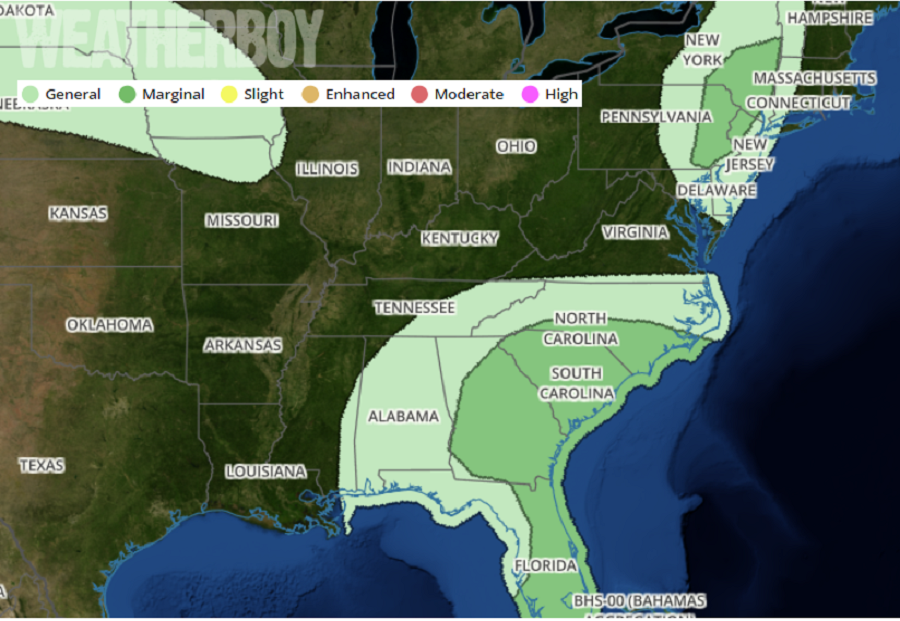
An area of low pressure moving into the eastern United States could set-off some severe thunderstorms in the northeast and southeast this afternoon and evening.

The latest water vapor loop from the GOES-East weather satellite shows a progressive shortwave trough moving into New York state. Lift ahead of this system will likely result in a fast-moving line of low-topped showers and a few thunderstorms this afternoon and evening over parts of eastern NY/PA. Strong wind aloft and steep low-level lapse rates will promote the risk of gusty and occasionally damaging wind gusts this afternoon. While severe storms will create large hail and isolated tornadoes from time to time, the environment isn’t very favorable for either today.


Latest RADAR does show some storms in the northeast and southeast this afternoon as of 3:20pm. Image: weatherboy.com

In the southeast, a slow-moving upper trough is moving eastward across Alabama today with the associated southwesterly mid-level winds extending from the northern Gulf of Mexico into Georgia and South Carolina. Visible satellite imagery from GOES-East shows considerable heating is occurring from central Georgia into the northern Florida peninsula, where conditions are ripe for severe storm development. Rather cold temperatures aloft may also set the stage for hail here, some of which could be large.  The area of greatest concern extends from southeast Georgia down to the east coast of the Florida peninsula.

Primary Sidebar

Sponsored Ad

Search

Latest News

  • Snow Drought Persists in Philadelphia, New York City, New Jersey, & Surrounding Areas
  • Earthquakes Rattle Los Angeles Area
  • Rocket Lab Has Spectacular Launch from Mid Atlantic This Evening
  • Mid-Week Winter Storm Expected in Northeast
  • New York City TV Weatherman Beaten-Up on NYC Subway
  • Freak Wind Accident at Denny’s Leaves 1 Dead, 2 Seriously Injured
  • Models Agree Snow is Coming to Mid Atlantic & Northeast, But Completely Disagree How and When
  • Weatherboy Sends Meteorology Students to National Tropical Weather Conference and is About to Do It Again
About | Careers | Contact | Contests
Terms | Privacy | Ad Choices
Weatherboy is a (R) Registered Trademark of isarithm LLC, All Rights Reserved.
All content herein is Copyright by Isarithm LLC 1997-2022