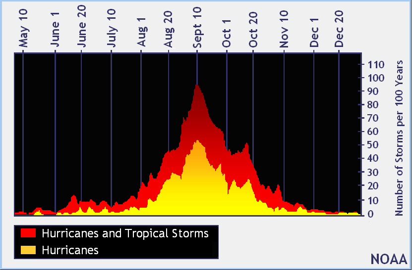
The traditional peak of Atlantic Hurricane Season is considered to be September 10; this year, that peak will be hurricane-less in a remarkably tame season to date. The National Hurricane Center’s (NHC) latest Tropical Outlook also shows there are no high odds of a new tropical cyclone forming over the next five days, giving people along the U.S. East and Gulf coast another reprieve from what is forecast to be an above-normal season.
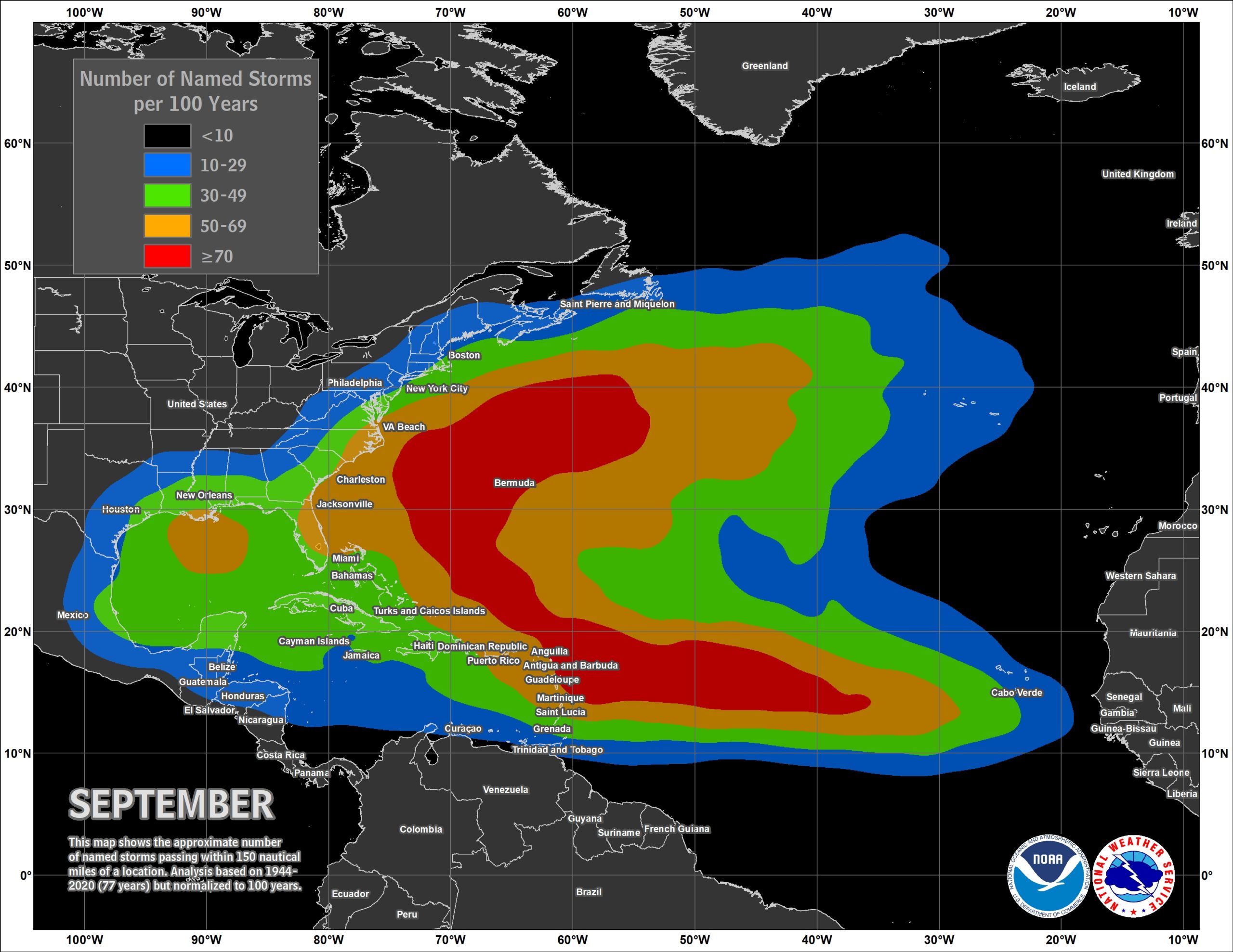
The official hurricane season for the Atlantic basin is from June 1 to November 30, but tropical cyclone activity sometimes occurs before and after these dates, respectively. The peak of the Atlantic hurricane season is September 10, with most activity occurring between mid-August and mid-October.
Thus far, the 2022 Atlantic Hurricane season has been relatively quiet compared to the super-hyperactive seasons of recent years that broke records. This year, Tropical Storm Alex formed five days after the start of the season, making it the first time since 2014 there wasn’t pre-season tropical cyclone formation in the basin. Roughly a month later, Tropical Storm Bonnie quickly formed and made landfall along the coasts of Costa Rica and Nicaragua; from there, it crossed Central America and maintained its tropical cyclone structure and name as it moved into the eastern Pacific Hurricane Basin. While Bonnie was crossing Central America, Tropical Storm Colin developed over coastal South Carolina and dissipated as quickly as it formed along the North Carolina coast the next day. The rest of July and all of August featured a tropical cyclone drought; this was the first season since 1997 that no tropical cyclones formed. After a 60 day stretch of no storm activity in the basin, Danielle and Earl formed in the Atlantic, becoming the first hurricanes of the season.
Yesterday, Hurricane Danielle weakened into a tropical storm and began its extratropical transition over the far north Atlantic.
Today, after brushing by Bermuda yesterday, Hurricane Earl is forecast to meet the same fate as Danielle. The NHC now expects Earl to complete its transition to a powerful hurricane-force extratropical low on Saturday and then steadily weaken through early Monday. Once Earl transitions into an extratropical low, the Atlantic will be void of any tropical cyclones –on the day that is traditionally the peak of such activity.
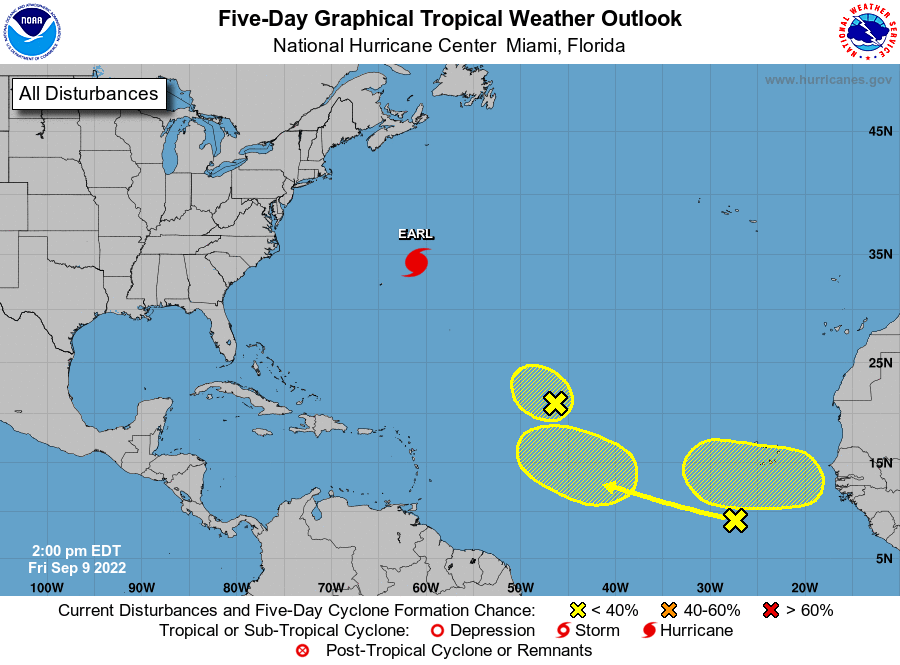
In the latest Tropical Outlook released by the NHC today, they are tracking three potential systems in the Atlantic; none have a high chance of developing into a tropical cyclone anytime soon.
The first system being studied is in the central Tropical Atlantic, where an area of low pressure located about 1,000 miles east of the Leeward
Islands is producing limited shower and thunderstorm activity, mostly displaced well to the northeast of the center of the low. According to the NHC, strong upper-level winds are expected to prevent significant development of this system while it moves generally west-northwestward or northwestward for the next day or so. The disturbance is then forecast to merge with a non-tropical system over the weekend, ending odds for tropical cyclone formation. As such, there’s only a low 10% chance that a tropical cyclone will form here over the next 48 hours.
The second system is in the eastern Tropical Atlantic. There, a tropical wave located several hundred miles south of the Cabo Verde Islands is producing a disorganized area of showers and thunderstorms. The NHC says no substantial development of this system is expected through the middle of next week while it moves westward or west-northwestward at 15 to 20 mph across the eastern and central tropical Atlantic. While there is zero chance of tropical cyclone formation here over the next 48 hours, those odds remain low at 10% over the next five days.
The third system is near the Coast of Africa, where another tropical wave is forecast to move off the coast of Africa by early next week. According to the NHC, some gradual development of the wave will be possible after it moves over water and heads generally westward over the far eastern Atlantic. While there’s no chance of tropical cyclone formation over the next 48 hours, those odds increase to 20% through the next five days. While they’re still low, they are the highest of the three systems the NHC is tracking today.
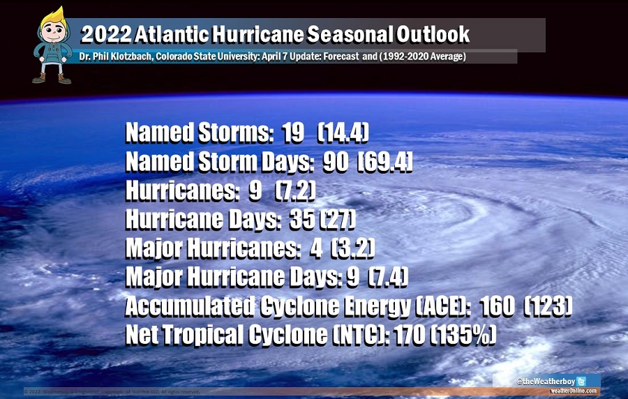
Earlier this year, leading tropical meteorology forecasters unveiled seasonal outlooks that called for a season with above-normal activity. The first was a study from Colorado State University, which was unveiled on April 7. That research endeavor, partially funded by Weatherboy, called for 19 named storms, 9 hurricanes, and 4 major hurricanes.
“So far, the 2022 hurricane season is exhibiting characteristics similar to 1996, 2000, 2001, 2008, 2012 and 2021. “Our analog seasons generally exhibited near- to somewhat above-normal Atlantic hurricane activity,” said Phil Klotzbach, research scientist in the Department of Atmospheric Science at Colorado State University (CSU) and lead author of the report at the time of the unveiling in April.
Dr. Phil Klotzbach in August said, “While continuing to forecast an above normal Atlantic hurricane season, we have lowered our forecast slightly and call for 18 named storms, including the three named storms that have already formed, eight hurricanes and four major hurricanes. While the Atlantic season has been very quiet since early July, we do anticipate things to pick up around August 15-20.”
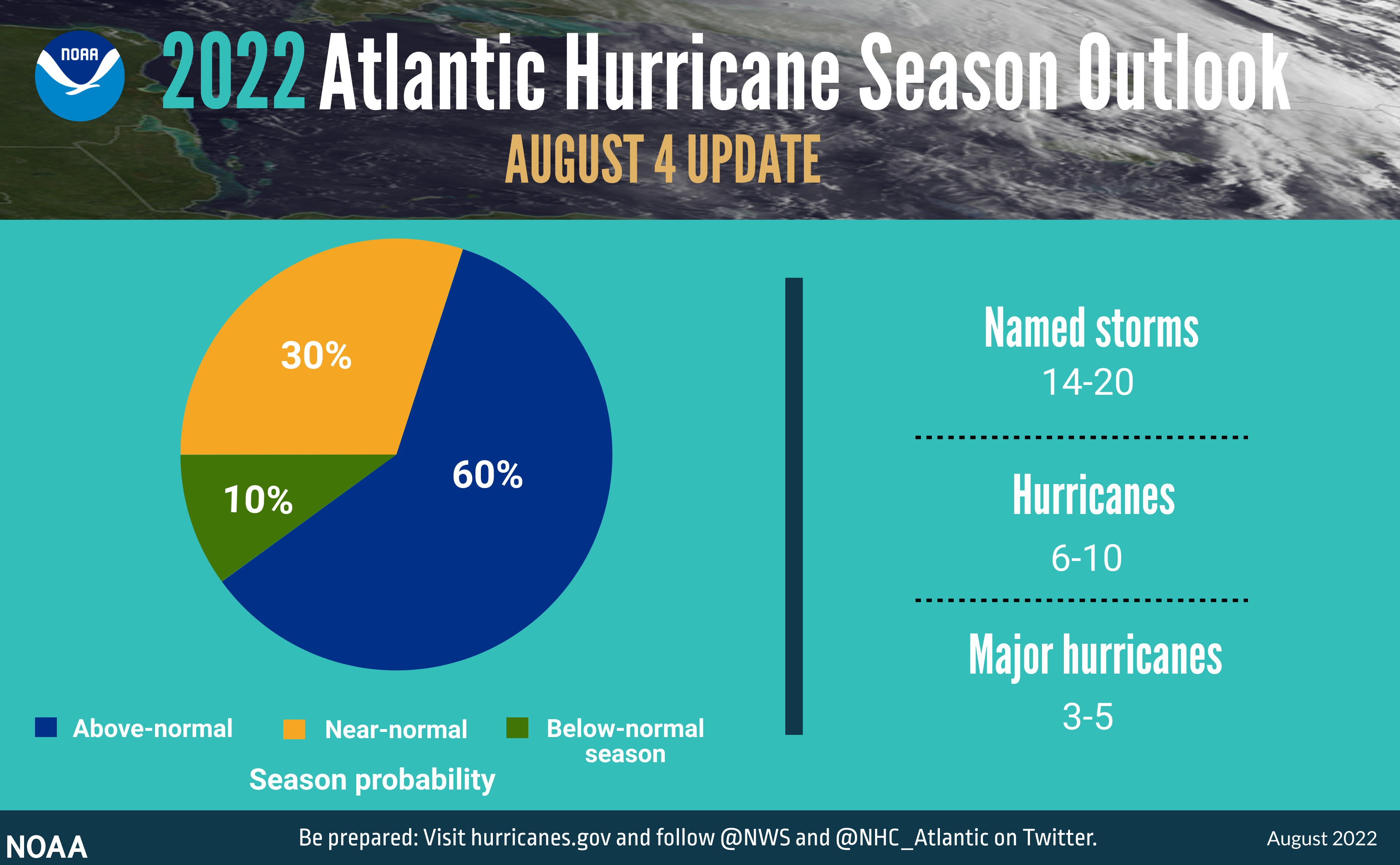
NOAA was in general agreement with the CSU outlook. “We’re just getting into the peak months of August through October for hurricane development, and we anticipate that more storms are on the way,” said NOAA Administrator Rick Spinrad, Ph.D., after an August update from NOAA was unveiled. In NOAA’s update issued then, the number of named storms initially forecast to be 14-21 was tweaked down to 14-20; the odds of an above-normal season shifted from 65% down to 60%. Even with the slight changes, NOAA forecasters still believe an especially active season is on the way.
However, that doesn’t appear to be the case –yet.
Dr. Klotzbach told us today that their outlook could be a bust. “The season has been surprisingly anemic so far,” Dr. Klotzbach said. “We’re currently running about 50% of normal for Atlantic Accumulated Cyclone Energy – an index accounting for storm frequency, intensity and duration.” The tropical meteorology expert added his theories on what’s happening this year: “In general, the season has been quieter than expected due to stronger shear and more dry air at mid-levels in the atmosphere than were anticipated. You can see a notable increase in shear from the Caribbean extending northeastward across the tropical and subtropical Atlantic. This is a classic pattern associated with a vigorous area of low pressure at upper-levels in the atmosphere, otherwise known as a Tropical Upper-Tropospheric Trough (TUTT). Normally La Nina results in a reduced TUTT, so the strong TUTT that has been present so far this year has been quite a surprise.”
“Right now, it’s certainly looking like we’re going to be busting this year’s seasonal forecast, but of course, we still have about 1/2 of the season left to go,” Dr. Klotzbach said. “And it was only two years ago where we had 6 hurricanes and 5 major hurricanes in October-November.”
“I urge everyone to remain vigilant as we enter the peak months of hurricane season,” said U.S. Secretary of Commerce Gina Raimondo. “The experts at NOAA will continue to provide the science, data and services needed to help communities become hurricane resilient and climate-ready for the remainder of hurricane season and beyond.”
“As is the case with all hurricane seasons, coastal residents are reminded that it only takes one hurricane making landfall to make it an active season for them,” the CSU updated outlook warns. “They should prepare the same for every season, regardless of how much activity is predicted.”
“Although it has been a relatively slow start to hurricane season, with no major storms developing in the Atlantic, this is not unusual and we therefore cannot afford to let our guard down,” said FEMA Administrator Deanne Criswell at a media event last month. “This is especially important as we enter peak hurricane season—the next Ida or Sandy could still be lying in wait.”
