The National Hurricane Center (NHC) has upgraded Tropical Storms Katia and Jose to hurricane status; the triple trouble of Irma, Jose, and Katia now spread across the Atlantic Hurricane Basin. The peak of the Atlantic Hurricane season, which extends from June through the end of November, is usually September 10 so this activity is normal for this time of year.
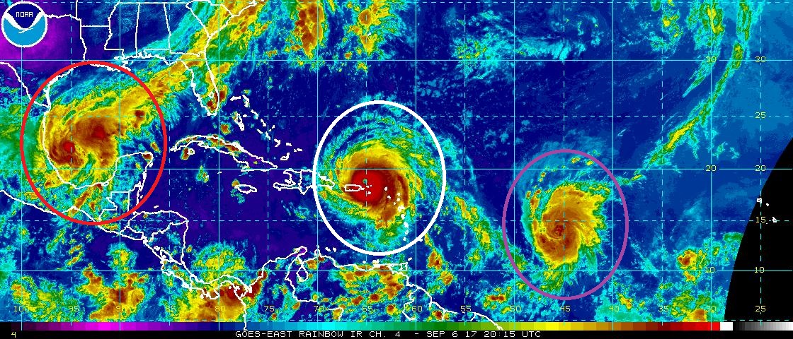
Hurricane Katia is located over the Gulf of Mexico. At 5pm, it had peak maximum sustained winds of 75mph and had a lowest central pressure of 992mb. Located at 21.7N 95.1W, Hurricane Katia was drifting southeast at 3mph. The Government of Mexico has issued a Hurricane Watch for the state of Veracruz there.
Hurricane Jose is located over the central Atlantic Ocean, near the area that gave birth to Irma. Jose is looking very impressive on the current satellite image and further intensification is possible. As of 5pm, Hurricane Jose had maximum sustained winds of 75mph and a central pressure of 994mb. It is located at 13.9N 45.8W . It is expected to move in the general path that Hurricane Irma took, possibly threatening areas hit hard by one hurricane with the next.
Lastly, the most impressive storm of this dangerous trio is Major Hurricane Irma, a destructive category 5 hurricane on the Saffir-Simpson scale. Hurricane Irma, as of 5pm, was located at 18.8N 65.4W and was moving to the west north west at 16mph. Maximum sustained winds are at 185mph with gusts over 200mph, making it one of the strongest hurricanes ever in the Atlantic Hurricane Basin. There is still a great deal of uncertainty with Irma’s future path, but the NHC says they may issue Hurricane Watches for Florida as early as Thursday.
Experts believe this Atlantic Hurricane Season, which runs through to the end of November, will be a busy one. Dr. Phil Klotzbach and the experts at Colorado State University updated their seasonal outlook again on July 5, showing a much more active than normal season expected. The National Oceanic and Atmospheric Administration (NOAA) also released their own forecast which shows this hurricane season to be likely more active than others.
