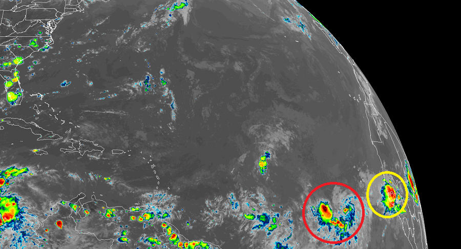
After a brief break from tropical cyclones in the aftermath of Hurricane Isaias’s impacts to the U.S. East Coast, it looks like things are heating up in the tropics again with tropical cyclone formation possible in the coming days. The National Hurricane Center (NHC) in Miami, Florida is tracking a disturbance in the central Atlantic while the Central Pacific Hurricane Center (CPHC) in Honolulu, Hawaii is tracking a disturbance southeast of Hawaii. Both systems could develop in the coming days; a strong disturbance moving off the coast of Africa today could also become a future threat.

Showers and thunderstorms associated with a tropical wave located a few hundred miles south-southwest of the Cabo Verde Islands continue to show signs of organization, according to the NHC. But the NHC adds that satellite-derived wind data from earlier this morning indicated that the circulation remains elongated. Nevertheless, environmental conditions appear conducive enough to support additional development of this system, and a tropical depression could form during the next few days while it moves generally westward at 15 mph across the tropical Atlantic. If this system were to continue developing and become a tropical storm, it would be named Josephine. The current record for the earliest “J” storm in the Atlantic is Jose on August 22, 2005, so if this system does become named in the coming days, it would shatter that record.
The Central Pacific is also being monitored for potential development. According to the CPHC, an area of low pressure will likely form around 1,450 miles southeast of Hilo, Hawaii in the coming days. Environmental conditions are expected to be generally conducive for gradual development, and a tropical depression could form late this week. If a storm were to form in the Central Pacific basin, it would be called Hone.
If any of these systems do form, it will take many days for them to reach land, if they even do.