The National Hurricane Center and the Central Pacific Hurricane Center say it is likely that tropical cyclones will take shape in hurricane basins around the U.S., with one likely to form south of Hawaii’s Big Island within the next 48 hours and another likely to form in the southern Gulf of Mexico within the next 48-72 hours. Of the two, the system developing around the Gulf of Mexico will post the greatest threat to the United States.
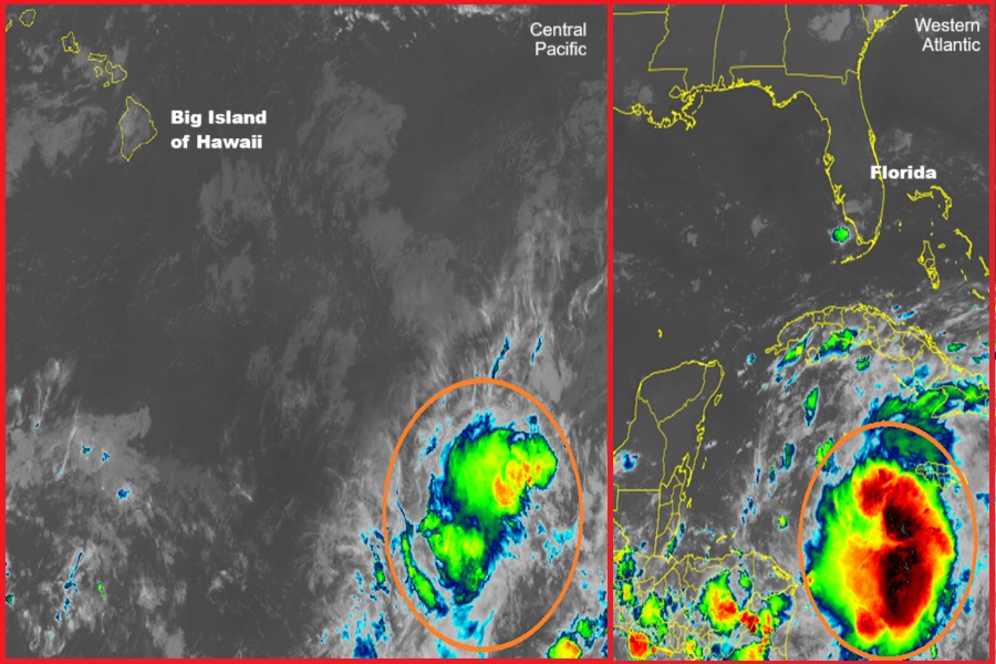
According to the latest Tropical Outlook issued by the Central Pacific Hurricane Center in Honolulu, Hawaii on the island of Oahu, there is a 60% chance that a tropical cyclone will form south of Hawaii within the next 48 hours. Approximately 1000 miles southeast of Hilo on the Big Island of Hawaii, an area of low pressure continues to produce disorganized showers and thunderstorms, while conditions aloft continue to produce outflow in all quadrants. The Central Pacific Hurricane Center (CPHC) says that environmental conditions appear conducive for some development over the next day or two, and a tropical depression could form as it moves westward at 5 to 10 mph. However, by Wednesday, the CPHC says that conditions will become gradually less conducive for development.

Even if a system does develop south of Hawaii, it will likely stay south of the islands as it moves west across the Pacific. While the forecast can still change in the coming days, both the American GFS and European ECMWF computer forecast models keep this system south of the Aloha State for the next several days, sparing the islands from any possible tropical cyclone winds or strong winds.
However, in the Gulf of Mexico, the United States Gulf Coast may not meet a similar fate with a developing system there.
According to the National Hurricane Center (NHC) in Miami, Florida, there is now a high chance that a tropical cyclone will take shape in the Gulf of Mexico in the coming days. Specifically, they say there is a 70% chance that a tropical cyclone will form over the next 48 hours but grow those odds to a high 90% that one will form over the next 7 days.
Disorganized showers and thunderstorms located over the northwestern Caribbean Sea and portions of Central America are associated with a broad area of low pressure. The NHC says that environmental conditions appear conducive for development of this disturbance, and a tropical depression or tropical storm is likely to form during the next few days while the system moves northward across the northwestern Caribbean Sea and into the southeastern Gulf of Mexico.

Regardless of development in the short term, this disturbance is expected to produce heavy rains over portions of Central America during the next several days. Interests in the northwestern Caribbean, the Yucatan Peninsula of Mexico, and western Cuba should closely monitor the progress of this
feature. Later this week, the system is forecast to move generally northward across the eastern Gulf of Mexico. The NHC warns, “Interests along the northern and northeastern Gulf Coast should also monitor the progress of this system.”
Unlike the tropical disturbance near Hawaii that computer forecast guidance says will miss the state, all computer models at this time say the disturbance in the Gulf of Mexico will hit the United States. Where it eventually hits and how strong it’ll be is still up in the air; most forecast models believe it will be at hurricane strength at landfall, with some models suggesting a storm as strong as Category 3 or 4 or greater.
