• Skip to primary navigation
  • Skip to main content
  • Skip to primary sidebar

Weatherboy

Weatherboy Weather News, Maps, RADAR, Satellite, and Forecasts.

  • Local
  • Earth Science News
  • RADAR
  • Current Warnings
  • Satellite
  • Current Maps
  • Forecast Maps
  • Video

Tropical Depression #3 Forms, But Will Die Soon After Becoming Chris

by Weatherboy Team Meteorologist - June 30, 2024

Tropical Depression #3 has formed; this is its forecast path into Mexico over the next 24 hours. Image: NHC


Tropical Depression #3 has formed in the Gulf of Mexico but is forecast to die soon; it will be moving into Mexico before it has a chance to develop into anything too significant.  The National Hurricane Center (NHC) does forecast the system to become a marginal tropical storm tonight prior to impacting Mexico early tomorrow morning;  Nevertheless, heavy flooding rains are expected in areas hit not long ago by Tropical Storm Alberto.

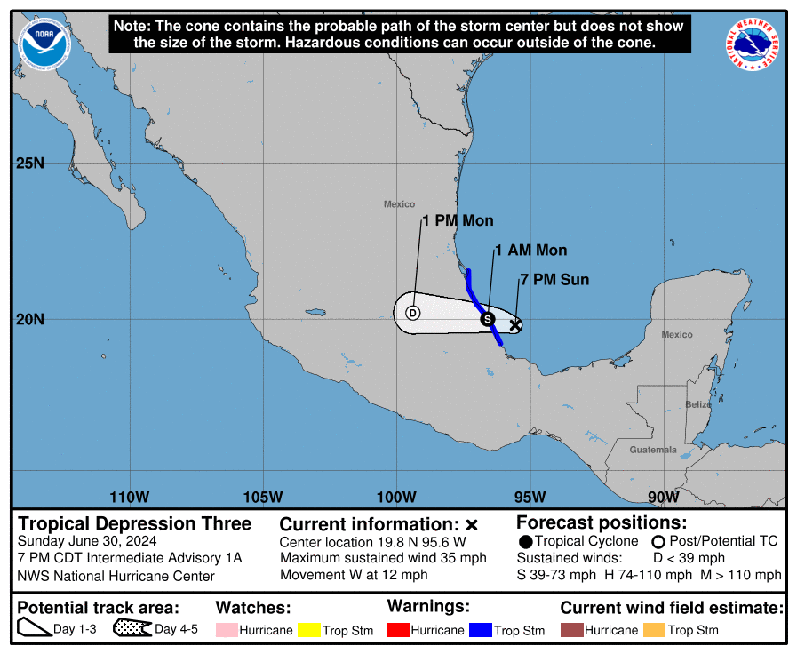
As of 7pm CDT, the center of Tropical Depression #3 was located at 19.8N 95.6W roughly 145 miles southeast of Tuxpan, Mexico. Maximum sustained winds are 35 mph and the present movement is west at 12 mph. The minimum central pressure is at 1006 mb or 29.71″.

The purple circle illustrates where Tropical Depression #3 is. Image: NOAA

The Government of Mexico has issued a Tropical Storm Warning from Cabo Rojo to Puerto Veracruz. A Tropical Storm Warning means that tropical storm conditions are expected somewhere within the warning area, in this case within the next 12 hours.

While maximum sustained winds are near 35 mph  with higher gusts now, the NHC expects some strengthening tonight and the cyclone is forecast to become a tropical storm before it reaches the coast later tonight. Once and if it becomes a named tropical storm, it will be called Chris. The system is then expected to weaken and dissipate after it moves inland over eastern Mexico.

This tropical cyclone is expected to produce rainfall totals of 4-8″ across portions of eastern Mexico into Monday, with localized maximum totals of 15″. According to the NHC, this heavy  rainfall will result in areas of flooding, with mudslides possible in areas of higher terrain.


Primary Sidebar

Sponsored Ad

Search

Latest News

  • New Satellite to Help Space Weather Forecasts Is Now Functioning and You Can Get the Data Yourself
  • Earthquake Swarm Building Near San Francisco in Time for Super Bowl LX
  • Earthquake Strikes Near Charleston, South Carolina where Worst East Coast Quake Struck
  • After Weather Delay, New Mechanical Issue Delays NASA’s Moon Mission
  • Earthquake Rattles Illinois Near St. Louis, Missouri
  • Groundhog Agrees with Climate Prediction Center: Many More Week of Winter Ahead
  • Massive X-Flare Explodes from Sun on Sunday Evening
  • East Coast Snow Storm Exits Coast With 20″+; Even Florida Got Snow
About | Careers | Contact | Contests
Terms | Privacy | Ad Choices
Weatherboy is a (R) Registered Trademark of isarithm LLC, All Rights Reserved.
All content herein is Copyright by Isarithm LLC 1997-2022

Insert/edit link

Enter the destination URL

Or link to existing content

    No search term specified. Showing recent items. Search or use up and down arrow keys to select an item.