• Skip to primary navigation
  • Skip to main content
  • Skip to primary sidebar

Weatherboy

Weatherboy Weather News, Maps, RADAR, Satellite, and Forecasts.

  • Local
  • Earth Science News
  • RADAR
  • Current Warnings
  • Satellite
  • Current Maps
  • Forecast Maps
  • Video

Tropical Storm Arlene Forecast to Weaken, Head South

by Weatherboy Team Meteorologist - June 2, 2023

Most of Tropical Storm Arlene's thunderstorms are to the north and east of the circulation center, which is over the Gulf of Mexico. Image: NOAA
Most of Tropical Storm Arlene’s thunderstorms are to the north and east of the circulation center, which is over the Gulf of Mexico. Image: NOAA


Tropical Storm Arlene, the second system of the 2023 Atlantic Hurricane Season, is forecast to weaken and head south, reducing the threat of heavy rain and gusty winds over Florida over the next 24 hours.

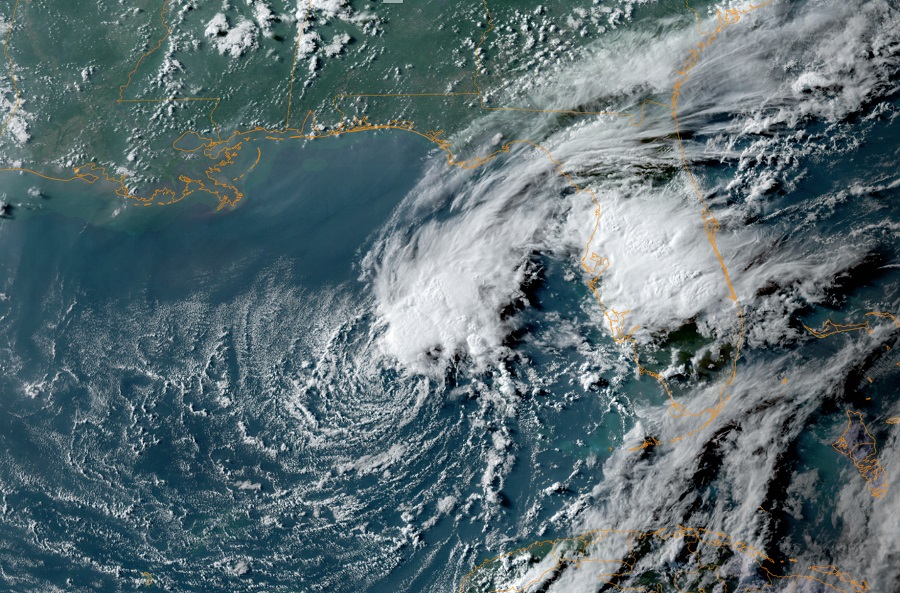
According to the National Hurricane Center (NHC) in Miami, Florida, Tropical Storm Arlene has changed little during the last few hours. The low-level center is still estimated to be near the southwest side of the main area of deep convection. The tropical-storm-force winds are confined to a relatively small region of about 60 nautical milesĀ  to the north of the center in the area of strongest thunderstorms. Although Arlene has strengthened a little today, the models are in good agreement that increasing vertical wind shear and notably drier air are expected to affect the cyclone beginning tonight. These conditions should cause a weakening trend, and Arlene is expected to become a remnant low on Saturday and dissipate on Sunday.

Latest forecast track for Tropical Storm Arlene. Image: NHC

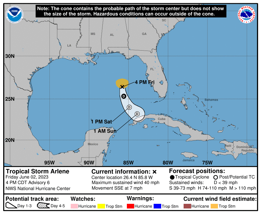
The tropical storm is currently moving south-southeast very slowly at about 5 kt and is being steered by a mid to upper level trough that it is embedded within. The NHC says they expect this overall motion is expected to continue for the next 24-36 hours, bringing the system closer to Cuba as it weakens.

For now, outer bands associated with the circulation of the tropical storm are lashing Florida with heavy rain and gusty winds. The potential for heavy rain will persist over portions of south and central Florida through Saturday. However, as the system weakens and heads south, the threat of rain will diminish throughout the day.

Primary Sidebar

Sponsored Ad

Search

Latest News

  • Tropical Storm Warnings Issued as Chantal Approaches East Coast
  • Tropical Storm Watches Issued for East Coast as Tropical Depression Forms
  • System to Impact Southeast U.S. This Weekend Says National Hurricane Center
  • Hurricane Center Says East Coast System Likely to Develop
  • National Hurricane Center Increases Odds of Cyclone Development Near Florida
  • Severe Weather Outbreak Likely in Mid Atlantic
  • July to Start with Severe Weather Event in New Jersey, Pennsylvania, Delaware, & Maryland
  • Tropical Storm Barry Forms; Additional Storm Possible Near Florida
About | Careers | Contact | Contests
Terms | Privacy | Ad Choices
Weatherboy is a (R) Registered Trademark of isarithm LLC, All Rights Reserved.
All content herein is Copyright by Isarithm LLC 1997-2022