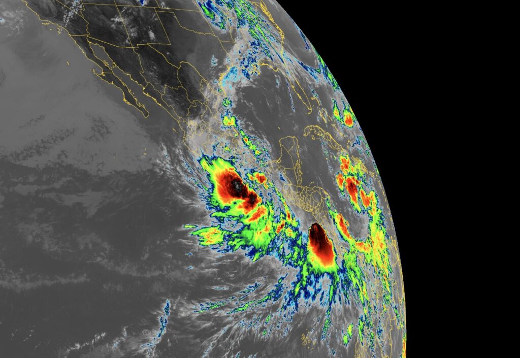
The National Hurricane Center is busy tracking two systems in the eastern Pacific; the first is Tropical Storm Boris and the other is Tropical Depression 3-E which was just upgraded to Tropical Storm Cristina moments ago. While the Pacific is busy, the Atlantic is quiet with no tropical storms or hurricanes on the horizon in the Atlantic Hurricane Basin. The future progress of Boris and Cristina and what’s left of them needs to be monitored over time for potential redevelopment in the Gulf of America.
Tropical Storm Boris is located about 45 miles west-southwest of Punta Maldonado, Mexico; it has maximum sustained winds of 40 mph and is drifting slowly to the north at only 3 mph. The minimum central pressure is 1002 mb or 29.59″.
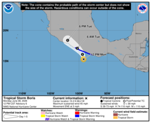
With Boris forecast to make landfall, the Mexican government has issued a Tropical storm Warning from Laguna de Chacahua to Tecpan de Galeana. A Tropical Storm Warning means that tropical storm conditions are expected somewhere within the warning area, in this case within 12 to 24 hours.
The National Hurricane Center (NHC) says Boris should gradually turn toward the northwest tonight. On the forecast track, the center of Boris is expected to reach the coast of Guerrero, Mexico, by this evening. While some slight strengthening is possible today, quick weakening is expected once the center reaches the coast. Boris is forecast to dissipate inland over Mexico by Tuesday.
Before Boris dissipates, significant rain is expected. 4-8″, with maximum totals of 12″ are possible across coastal portions of the Mexican states of Guerrero and Oaxaca through Tuesday. This rainfall may produce life-threatening flooding and mudslides, especially in areas of steep terrain.
Meanwhile to the south of Boris, Cristina is taking shape. Tropical Depression 3E formed to the south of Boris off the coast of Nicaragua earlier today. The National Hurricane Center says winds are now up to 45 mph, making it the third named tropical storm of the 2026 Hurricane Season. For now, Tropical Storm Christina is located about 100 miles west-southwest of Managua, Nicaragua and about 170 miles southeast of San Salvador, El Salvador. The storm is moving to the north slowly at 7 mph while the minimum central pressure is down to 1002 mb or 29.59″.
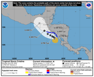
The government of Nicaragua has issued a Tropical Storm Warning for the coast of Nicaragua from Puerto Sandino to the border of Honduras; the government of El Salvador had issued a Tropical Storm Warning for the entire coast of El Salvador; the government of Honduras has also issued a Tropical Storm Warning for its Pacific coast.
While Christina is moving toward the north near 7 mph now, a turn toward the northwest is expected Tuesday morning. The system should parallel the coast through Thursday. On the forecast track, the storm will be moving near the coast of Nicaragua, Honduras and El Salvador through Tuesday. Some gradual strengthening is forecast during the next couple of days but the storm isn’t expected to reach hurricane strength before landfall.
This new storm is projected to cause rainfall totals of 4-8″ with maximum totals of 12″ possible across coastal portions Nicaragua, Honduras, El Salvador, and Guatemala through Thursday morning. This rainfall may produce life-threatening flooding and mudslides, especially in areas of steep terrain.
