According to the National Hurricane Center (NHC) in Miami, Florida, Tropical Storm Dalila is close enough to Mexico to lash its coast with strong gusty winds and heavy rains; 6″ or more of rain is possible before the storm moves away.
As of the latest update from the NHC, Dalila is located about 175 miles south of Manzanillo, Mexico. With a minimum central pressure of 996 mb or 29.42″, the storm has maximum sustained winds now of 60 mph.
Due to its close proximity to the coast, the government has issued a Tropical Storm Warning from Tecpan De Galeana to Cabo Corrientes along the Mexican coast. A Tropical Storm Warning means that tropical storm conditions are expected somewhere within the warning area within 36 hours. While Tropical Storm warnings are in effect, Dalila is not expected to make landfall on Mexico.
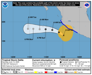
Tropical Storm Dalila is moving toward the northwest near 12 mph now. According to the NHC, a gradual west-northwest to westward turn is expected later today into Sunday. On the forecast track, the center of Dalila is forecast to remain offshore the southwestern coast of Mexico. Some additional strengthening is possible today, with a weakening trend beginning on Sunday.
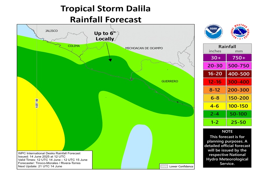
Additional rainfall amounts of 3-6″ are expected across portions of the Mexican states of Michoacán and Guerrero
through Sunday morning, with localized storm totals up to 9″ near the coast. This rainfall will lead to areas of flooding and mudslides, especially in areas of steep terrain near the coast.
Swells generated by Tropical Storm Dalila will affect portions of the coast of southwestern Mexico during the next couple of days. These swells are likely to cause life-threatening surf and rip current conditions.
