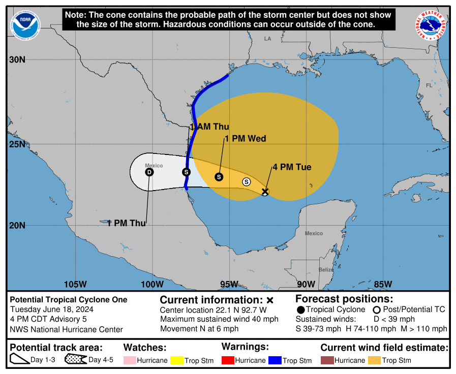
A Potential Tropical Cyclone is approaching the Mexican and Texas coast from the east, prompting the National Hurricane Center to expand Tropical Storm Warnings north as the storm moves to the west. The disturbance, officially known as Potential Tropical Cyclone One, is forecast to become a tropical storm by Wednesday afternoon before making landfall on the Gulf Coast of Mexico on Thursday morning. But because of its size, strong winds and heavy rain will lash up most of the Texas Gulf Coast.
With the continued lack of a well-defined center and little central convection, the system is still being designated as a potential tropical cyclone at this time. However, forecast models used by National Hurricane Center (NHC) meteorologists show that this system will gradually consolidate over the next 24 hours, and the center could be well defined enough by then to designate the system as a tropical cyclone. Even if that occurs, only modest intensification is forecast before the center reaches land due to the continued broad nature of the circulation.
If the system becomes an official Tropical Storm, it would be given the name Alberto, the first name of the 2024 Atlantic Hurricane Season.
Regardless of the exact track of the low, this system will have a large area of heavy rains, moderate coastal flooding and tropical-storm-force winds well north of the center. “Importantly, the official wind speed probabilities are likely underestimating the chances of tropical-storm-force winds along the Texas coast because of the unusually large and asymmetric area of strong winds on the northern side of the circulation,” warns the NHC. Because of that, they decided to issue Tropical Storm Warnings up the Texas coast up to San Luis Pass.

“The disturbance is very large with rainfall, coastal flooding, and wind impacts likely to occur far from the center along the coasts of Texas and northeastern Mexico,” said the NHC in their latest advisory for the storm.
Rainfall associated with Potential Tropical Cyclone One will impact large regions of Central America, north across northeastern Mexico and into South Texas. This rainfall will likely produce considerable flash and urban flooding along with new and renewed river flooding. Life-threatening flooding and mudslides are likely in areas of higher terrain across the Mexican states of Coahuila and Nuevo Leon, including the city of Monterrey. Moderate coastal flooding is likely along much of the Texas Coast through midweek.
Tropical storm conditions are expected to begin tonight or Wednesday along portions of the Texas coast south of San Luis Pass and along portions of the coast of northeastern Mexico within the Tropical Storm Warning area.