With Potential Tropical Cyclone #1 expected to grow into Tropical Storm Alex today, the National Hurricane Center has issued Tropical Storm Warnings for portions of the Gulf Coast of Florida; they have also been expanded to include portions of the East Coast and the Bahamas too.
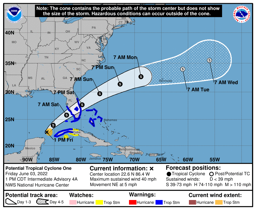
As of the latest advisory from the National Hurricane Center (NHC), the system officially known as Potential Tropical Cyclone #1 is located at 22.6 N 86.4 W which is roughly 395 miles southwest of Fort Meyers, Florida and about 150 miles north-northeast of Cozumel. Maximum sustained winds are now up to 40 mph. However, Hurricane Hunter Aircraft investigating the storm has seen little change in organization and structure within the storm system over the last several hours. Because of that lack of structure, the system has yet to be classified as a Tropical Storm.
But with tropical storm conditions likely, several warnings and watches have been issued. A Tropical Storm Warning is in effect for the Florida Keys including the Dry Tortugas, Florida Bay, the west coast of Florida south of the Middle of Longboat Key to Card Sound Bridge, the east coast of Florida south of the Volusia/Brevard County Line to the Card Sound Bridge, all of Lake Okeechobee, the Northwestern Bahamas, and the Cuban provinces of Pinar del Rio, Artemisa, La Habana, and Mayabeque. A Tropical Storm Watch is in effect for the Cuban provinces of Matanzas and the Isle of Youth. A Tropical Storm Warning means that tropical storm conditions are expected somewhere within the warning area within 36 hours while a Tropical Storm Watch means that tropical storm conditions are possible somewhere within the watch area within 48 hours.
The system has been moving to the northeast at about 5 mph and the NHC expects this motion to continue today with a gradual increase in forward speed later today. On the forecast track, the system should move across the southeastern Gulf of Mexico through tonight, across the southern and central portions of the Florida Peninsula on Saturday, and then over the southwestern Atlantic north of the northwestern Bahamas Saturday afternoon through Sunday.

Maximum sustained winds are near 40 mph with higher gusts. The system is expected to develop a well-defined center and become a tropical storm later today, and some slight strengthening is possible while it approaches Florida today and tonight. The NHC says that additional strengthening is possible after the system moves east of Florida over the western Atlantic late Saturday and Sunday.
Once the storm reaches tropical storm status, it will be named Alex.
The storm will produce extremely heavy rain, strong winds, and storm surge flooding.
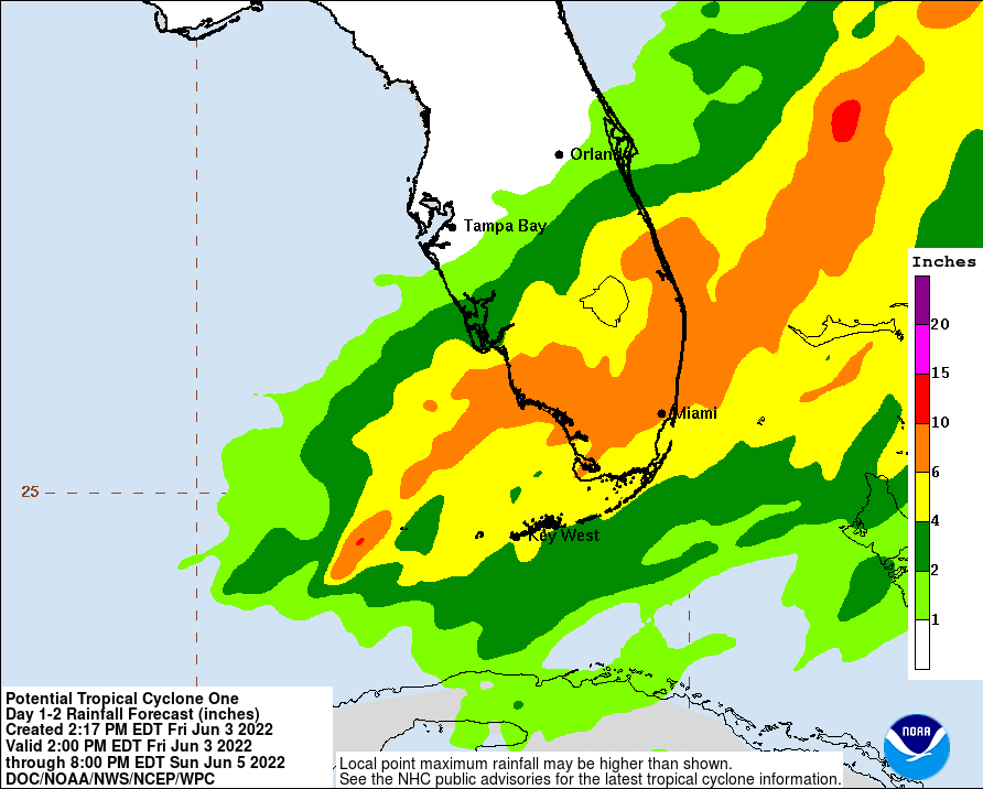
Heavy rain will begin to affect Central Florida, South Florida and the Keys today through Saturday, and affect northwestern Bahamas tonight through Saturday. Florida will see 4-8″ of rain, with some isolated areas getting up to a foot. This rain could produce considerable flash and urban flooding. In the Northwestern Bahamas, 3-6″ of rain with isolated maximums up to 10″ is possible, where flooding is likely too.
Tropical storm force wind conditions are expected in the warning area in Cuba today and tonight, in Florida tonight and on Saturday, and in the northwestern Bahamas on Saturday. Tropical storm conditions are possible in the watch area in Cuba today and tonight. Isolated tornadoes are also possible across southern Florida as the system spins through.
The combination of storm surge and the tide will cause normally dry areas near the coast to be flooded by rising waters moving inland from the shoreline. The water could reach 1-3′ across Marco Island to the Card Sound Bridge; 1-2′ is possible from the middle of Longboat Key to Marco Island, Charlotte Harbor, and the Florida Keys and Dry Tortugas. On the east coast, from
Card Sound Bridge to North Miami Beach, including Biscayne Bay, a 1-2′ storm surge is possible too. Surge-related flooding depends on the relative timing of the surge and the tidal cycle, and can vary greatly over short distances.