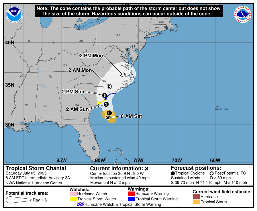
The National Hurricane Center (NHC) has upgraded Tropical Depression #3 into Tropical Storm Chantal, the third named storm of the 2025 Atlantic Hurricane Season. With a tropical storm headed to the East Coast, the NHC has also issued Tropical Storm Warnings and Watches for a portion of the coastline along the Carolinas. Flooding rains, storm surge, and gusty winds are expected as Chantal approaches the coast.
As of the latest advisory from the NHC, Chantal was located at 30.9N 79.0W which is 150 miles south-southeast of Charleston, South Carolina and about 240 miles south-southwest of Wilmington, North Carolina. The storm has a minimum central pressure of 1009 mb or 29.80″.
Tropical Storm Chantal is moving slowly toward the north near 2 mph. According to the NHC, a slow motion toward the north-northwest is expected to begin later today, followed by a turn to the northeast by Sunday night. On the forecast track, the center of Chantal is expected to move across the coast of South Carolina Sunday morning.
Chantal’s maximum sustained winds have increased to near 40 mph with higher gusts. The NHC says some additional strengthening is expected before Chantal reaches the coast. However, Chantal is not forecast to grow into a hurricane prior to landfall.
With the system upgraded to a tropical storm, some of the Tropical Storm Watch area has been upgraded to a Tropical Storm Warnings; specifically, this impacts the area extending from the South Santee River in South Carolina to Cape Fear, North Carolina. A Tropical Storm Watch is in effect for Edisto Beach to South Santee River, South Carolina.
A Tropical Storm Warning means that tropical storm conditions are expected somewhere within the warning area, in this case within the next 12 to 24 hours. A Tropical Storm Watch means that tropical storm conditions are possible within the watch area, in this case within the next 12 hours.
“Interests elsewhere along the southeast coast of the United States should monitor the progress of Chantal,” cautions the NHC.
Tropical Storm Chantal is expected to produce heavy rainfall across portions of the coastal plain of the Carolinas
today through Monday. Storm total rainfall of 2-4″, with local amounts to 6″, is expected. This heavy rain could create an elevated risk for flash flooding.
The combination of storm surge and tide will cause normally dry areas near the coast to be flooded by rising waters moving inland from the shoreline. A storm surge of 1-3′ is possible in the area between South Santee River, South Carolina to Cape Fear, North Carolina; a 1-2′ storm surge is possible from Edisto Beach, South Carolina to the South Santee River in South Carolina.
The tropical storm is expected to bring life-threatening surf and rip currents along the coast from northeastern Florida to the Mid-Atlantic states during the next couple of days.
While most impacts will be to the Carolinas, the general weather pattern with Chantal’s remnants will create conditions ripe for heavy downpours up the U.S. East Coast. At the surface, high pressure will be located offshore with return flow developing on Sunday through Monday as tropical cyclone remnants dissipate across the Carolinas. This setup will result in a slight warming trend in temperatures, and a more significant increase in dewpoints and humidity especially by Monday for places like Virginia, Delaware, Maryland, and New Jersey. With an abundance of moisture, the early part of the new week could feature heavy, potentially flooding, rains up the coast.
