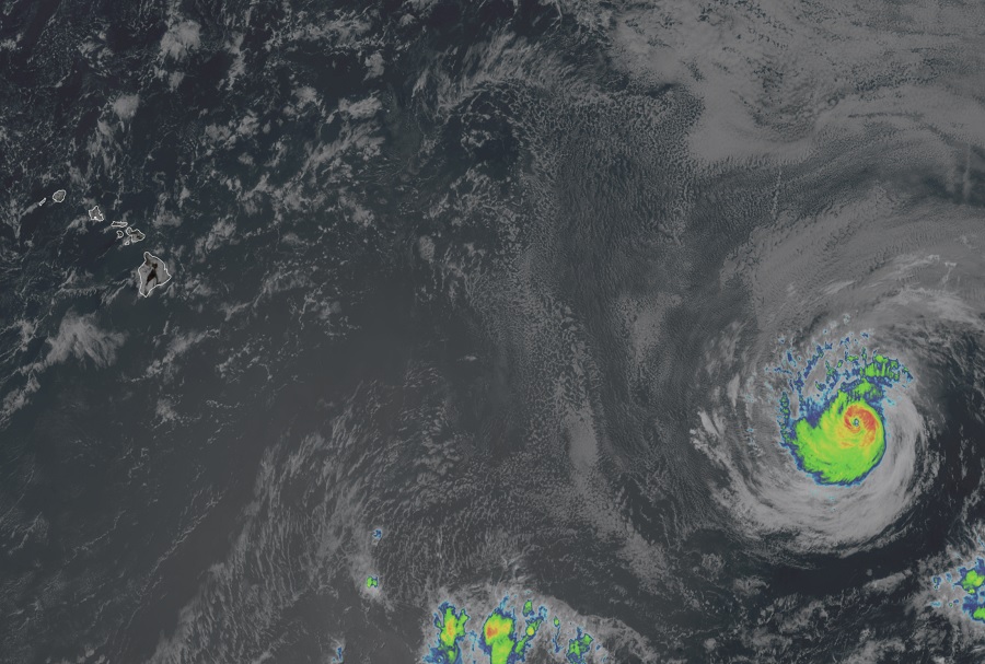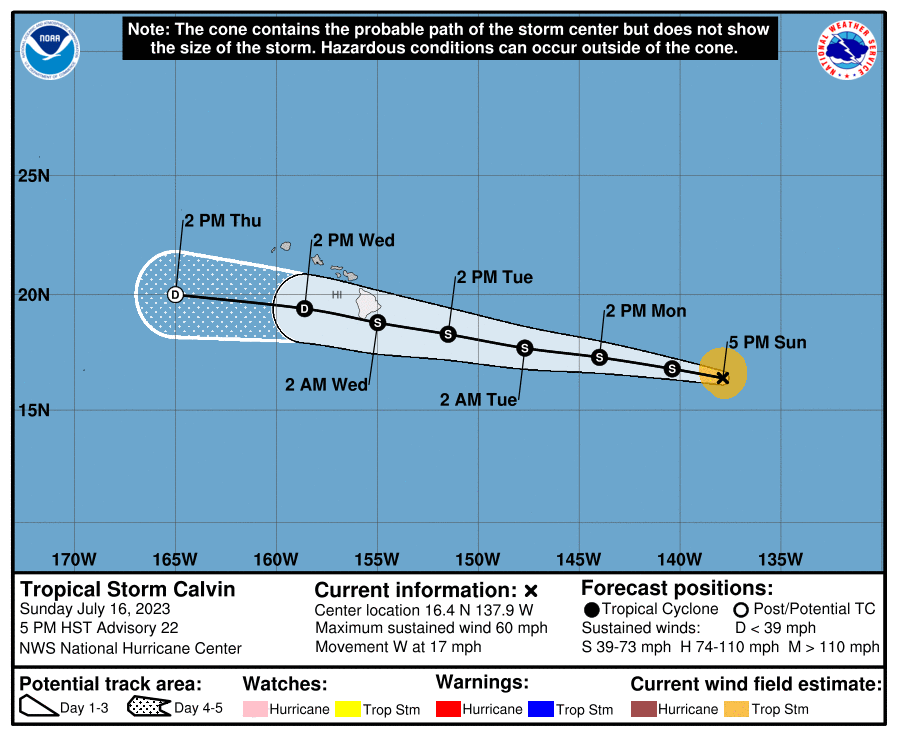
The National Hurricane Center could issue Tropical Storm Watches for the Aloha state of Hawaii tonight ahead of Tropical Storm Calvin’s likely impact into the Big Island of Hawaii late Tuesday into Wednesday. Calvin was once a ferocious category 3 hurricane but has significantly weakened to a tropical storm with maximum sustained winds of only 60 mph. However, as the residents of Hawaii’s Big Island know, even tropical storms can create catastrophic conditions on the island, as was the case when Tropical Storm Iselle smashed into the Big Island in 2014. That storm was the third costliest tropical cyclone to strike Hawaii with more than a hundred million dollars in damages and 1 fatality.
A Tropical Storm Warning means that tropical storm conditions are expected somewhere within the warning area within 36 hours while a Tropical Storm Watch means that tropical storm conditions are possible somewhere within the watch area within 48 hours. By the time the next advisory update is issued at 11 pm this evening Hawaii Time (5 am Eastern Time), criteria could be met to issue Tropical Storm Watches for at least the Big Island of Hawaii.
Heavy rain, gusty potentially damaging winds, and rough surf are expected as Calvin strikes the Big Island, likely not far from where Iselle hit in 2014.
In August of 2014, Tropical Storm Iselle hit the Big Island of Hawaii in the island’s southern Ka’u district. Meteorologically, the storm rapidly fell apart, quickly becoming only a remnant area of low pressure the day after landfall. Nevertheless, Iselle brought significant damage to Hawaii. While hurricane strength gusts were recorded at Mauna Kea on the Big Island, the entire state except for Niihau experienced tropical storm force wind gusts of over 39 mph. Strong winds knocked down large trees and powerlines and unroofed homes around Hilo. Parts of the Big Island saw more than a foot of rain which produced considerable flooding and flood damage. 6-10′ swells pounded the eastern shores of the Hawaiian Islands. More than 1,000 coffee trees, over 2,000 macadamia nut trees, and more than 60% of the state’s papaya crop were badly damaged or destroyed. Over 250 property owners reported damage to their homes with 11 totally destroyed and 28 with major damage. The overall damage toll was pegged at about $325 million, making it one of the most costly natural disasters to strike Hawaii after 1992’s Hurricane Iniki and 1982’s Hurricane Iwa. Iselle was responsible for one death: a 19 year old woman was swept away by flood waters while hiking around in a closed state park.

For now, it appears Tropical Storm Iselle won’t pack nearly as much of a punch as Iselle did, but problems are still likely. Flooding rains will close roads and possibly create rockslide situations along the island, especially on the eastern, windward side. The National Weather Service reminds people: “Turn around, don’t drown; never drive through flooded roads.” Specifically, storm total rainfall amounts of 4-7″ are possible along windward areas of the Big Island of Hawaii with lower amounts of about 1-4″ expected elsewhere in the state. Gusty winds will likely topple branches and perhaps trees, taking wires down with them. People may experience extended power outages as a result of such damage. Tropical storm force winds will also blow about any objects not secured: lanai and lawn furniture, garbage cans, awnings and tents, and other objects that could knock over or fly in strong winds should be brought inside or made very secure outside. Because only tropical storm force winds are expected, widespread damage to buildings and homes or even forested areas is not expected.
Surf will also be rough and even the most experienced surfers should stay out of the ocean until the storm passes. Swells generated by Calvin are expected to begin reaching the Hawaiian Islands during the next couple of days. These swells are likely to cause life-threatening surf and rip current conditions. Rough surf and high winds at sea will also create dangerous conditions for boaters; anyone in a small or large craft should check local and regional alerts before departing port.
Reliable weather records only go back to 1950 on Hawaii’s Big Island. In the time since, there is no record of a hurricane landfalling on the Big Island of Hawaii. Tropical Storm Iselle in 2014 became only the second tropical storm, and the strongest, to landfall on the Big Island. The only other storm to do so prior was in 1958. Another storm, a weaker Tropical Storm Darby, struck the Big Island in 2016, bringing flooding rains to the South Kohala, Ka’u, and Hamakua districts. Darby’s top winds were only 40 mph compared to Iselle’s 60 mph winds.
Calvin is expected to face the same fate as Darby and Iselle, with its circulation completely disrupted by the tall volcanic mountains on the Big Island. The current National Hurricane Center forecast keeps the system south of the rest of the Aloha State, although moisture associated with the system could spread state-wide.