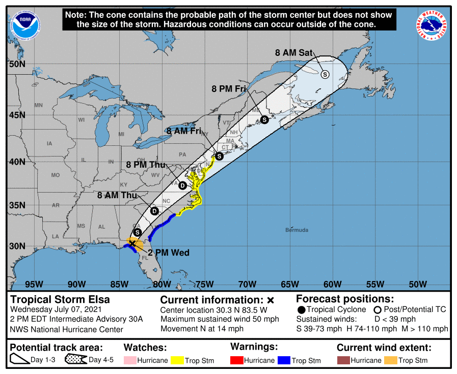
The National Hurricane Center in Miami, Florida has expanded Tropical Storm Watches north to Sandy Hook, New Jersey as Tropical Storm Elsa heads north. Wind-whipped rains will lash the coast from Florida north to New England over the next 36 to 48 hours before the storm finally exits the northeast coast late Friday. Additional watches and warnings may need to be issued up the Mid Atlantic and New England coasts later today or tomorrow.
As Elsa moves across the western and northern Florida Peninsula today, heavy rainfall may result in considerable flash, urban, and isolated moderate river flooding. Heavy rainfall across southeast Georgia, South Carolina, North Carolina, and southeastern Virginia may result in isolated flash and urban flooding, with considerable flash and urban flooding possible across southeast Georgia and the Lowcountry of South Carolina. Heavy rainfall across the Northeast and New England Thursday and Friday could lead to isolated flash and urban flooding.
There is still a danger of life-threatening storm surge along portions of the west coast of Florida today, and a Storm Surge Warning is in effect for that area.
Although the center of Elsa is expected to remain inland of the coastline from Georgia through the Carolinas during the next day or two, tropical storm conditions are expected along much of the coasts of Georgia and South Carolina. Tropical storm conditions are also possible along the coast of the mid-Atlantic states by Thursday night or Friday.
The latest forecast from the National Hurricane Center does call for Elsa to weaken to a tropical depression by tomorrow morning over the interior Carolinas, but is expected to re-intensify back to a tropical storm as it approaches the Maryland, Delaware, and New Jersey coasts.
It is possible Elsa will make additional landfalls up the coast as a tropical storm in New Jersey, across Long Island, and along the southeastern New England coast. While the center will be close to the coast, winds and rains will extend out from the center of the storm on both the west and east sides. This means wind-whipped rains will also impact places like eastern Pennsylvania and southern Upstate New York as the storm heads up the coast and out to sea.
For now, tropical storm watches are up the Jersey Shore and include the Chesapeake Bay south of North Beach, the tidal Potomac south of Cobb Island, and Delaware Bay south of Slaughter Beach. A Tropical Storm Warning means that tropical storm conditions are expected somewhere within the warning area while a tropical Storm Watch means that tropical storm conditions are possible within the watch area.