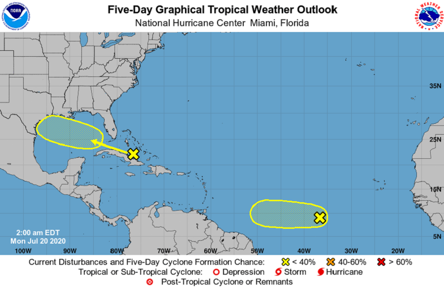
The National Hurricane Center (NHC) in Miami, Florida is keeping a close eye on two areas of concern over the tropical Atlantic for potential tropical cyclone development. The first is near Cuba and could develop into a tropical system in the Gulf of Mexico in the coming days; the other is in the central Atlantic, far from land for now.
According to this morning’s Tropical Outlook from the NHC, disorganized showers and thunderstorms over the central Bahamas, central Cuba, and adjacent Atlantic waters are associated with a tropical wave. The NHC believes that environmental conditions could become a little more conducive for development of this system over the Gulf of Mexico. This system is expected to move west-northwestward through the Straits of Florida today, over the southeastern Gulf of Mexico by Tuesday, across the central Gulf on Wednesday, and reach the northwestern Gulf on Thursday. If something does form here, it will take time. For now, the NHC says there’s only a 20% chance that a tropical cyclone will form in the Gulf of Mexico over the next 5 days.
The second system being monitored by the NHC is over the central Atlantic. A tropical wave located more than 900 miles west-southwest of the Cabo Verde Islands is producing a small area of disorganized showers and thunderstorms. According to the NHC, environmental conditions are expected to be marginally conducive for development of this system during the next few days while it moves westward at 10 to 15 mph over the tropical Atlantic. By Friday and over the weekend, conditions are forecast to become less favorable for tropical cyclone formation. Like the system approaching the Gulf of Mexico, the National Hurricane Center believes there’s only a 20% chance of tropical cyclone development here over the next five days.
There’s no other areas within the Atlantic basin being monitored for potential development. The 2020 Atlantic Hurricane season runs through to the end of November; peak storm activity typically happens in September.
