In a first for the record books, it appears the Gulf Of Mexico will be home to two hurricanes in the coming days: Laura and Marco. Developing tropical cyclones are forecast to eventually become hurricanes and move into the Gulf of Mexico over time, likely coming on-shore along the U.S. Gulf Coast.
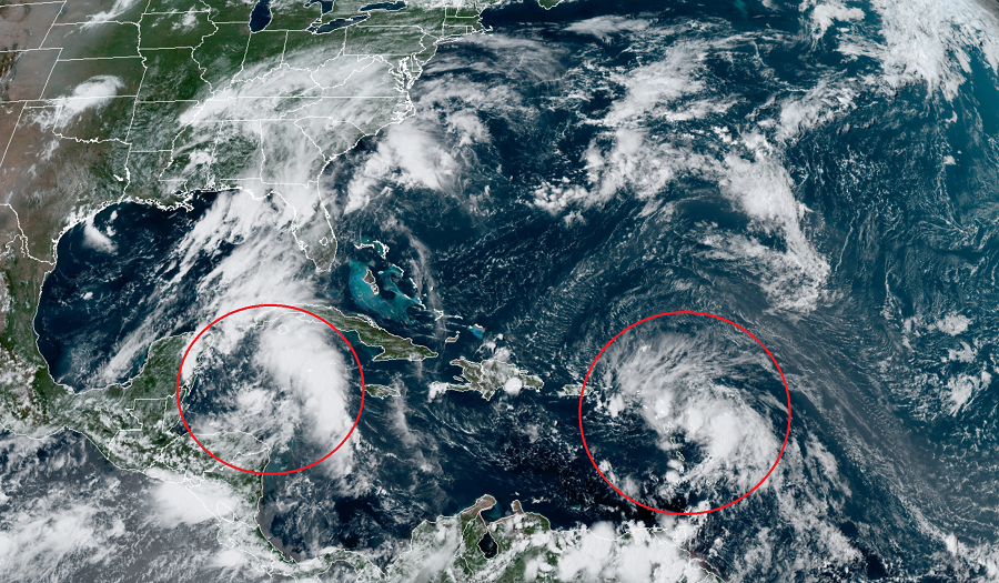
The first storm of concern is Tropical Storm Laura. As of the latest advisory from the National Hurricane Center (NHC), Laura was located roughly 175 miles east south east of the Northern Leeward Islands and had maximum sustained winds of 45 mph. The NHC is forecasting that this storm will continue to march towards the west, with a generally west-northwestward motion at a faster forward speed in the coming days. On the forecast track, the center of Laura will move near or over portions of the Leeward Islands later today, near or over Puerto Rico Saturday morning, and near the northern coast of Hispaniola late Saturday and early Sunday. As it moves away from Hispaniola and closer to Florida, it is expected to grow from a tropical storm into a hurricane. Where exactly it goes from there and how strong it gets remains in doubt; however, the NHC does expect it to reach the Gulf of Mexico as a hurricane.
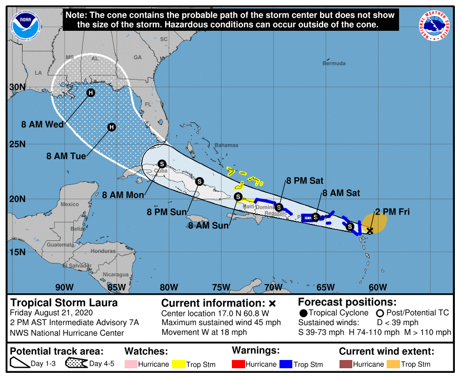
For now, Laura has triggered the issuance of Tropical Storm Watches and Warnings. The government of the Dominican Republic has issued a Tropical Storm Warning for the northern coast of the Dominican Republic from Cabo Engano to the border with Haiti. A Tropical Storm Warning is also in effect for Puerto Rico including Vieques and Culebra, the U.S. and British Virgin Islands, Saba and St. Eustatius, St. Maarten, St. Martin and St. Barthelemy, Antigua, Barbuda, St. Kitts, Nevis, Anguilla, and Montserrat. A Tropical Storm Watch is in effect for the northern coast of Haiti from Le Mole St. Nicholas to the
border with the Dominican Republic and for the southeastern Bahamas including the Turks and Caicos Islands. A Tropical Storm Warning means that tropical storm conditions are expected somewhere within the warning area. A Tropical Storm Watch means that tropical storm conditions are possible within the watch area, generally within 48 hours.
Laura is expected to produce 3-6″ of rain over Puerto Rico and the Virgin Islands, the Dominican Republic, and the southern Haitian Peninsula through Sunday, with some localized amounts up to 8″ possible along eastern portions and the southern slopes of Puerto Rico, as well as over Haiti and the Dominican Republic. This heavy rainfall could lead to flash and urban flooding, as well as an increased potential for mudslides with minor river flooding in Puerto Rico. 1-3″ of rain, with isolated amounts up to 5″, are forecast over the remainder of Haiti, the northern Leeward Islands, the Turks and Caicos and southeast Bahamas.
While Laura continues to grow, so does Tropical Depression #14. This tropical depression is forecast to grow into a tropical storm today; when it does so, it’ll be named Marco. Marco is then forecast to become a hurricane prior to a landfall on the Yucatan Peninsula. After moving across the Yucatan and entering the Gulf, Marco is expected to join Laura as a hurricane in the Gulf of Mexico.
For now, heavy rain and gusty winds are lashing portions of Central America; meanwhile, watches and warnings are being expanded ahead of the storm. Right now, a Hurricane Watch is in effect from Punta Herrero to Cancun in Mexico. A Tropical Storm Warning is in effect for the Bay Islands of Honduras and from Punta Herrero to Cancun, Mexico. A Tropical Storm Watch is in effect for the area north and west of Cancun to Dzilam, Mexico. A Hurricane Watch means that hurricane conditions are possible within the watch area. A watch is typically issued 48 hours before the anticipated first occurrence of tropical-storm-force winds, conditions that make outside preparations difficult or dangerous.

In the latest update from the NHC, Tropical Depression #14 was located about 180 miles east northeast of Isla Roatan, Honduras, and about 280 miles southeast of Cozumel, Mexico. This system is moving slowly northwestward for now and is forecast to increase speed by Sunday and Monday. On the forecast track, the center of the depression will continue to move away from the coast of Honduras today and will approach the east coast of the Yucatan Peninsula of Mexico on Saturday. The center will then cross the northeastern part of the Yucatan Peninsula Saturday night and move over the central Gulf of Mexico toward the northwestern Gulf on Sunday and Monday. While the depression only has maximum sustained winds of 35 mph for now, the NHC is forecasting strengthening over the next couple of days. The depression is expected to become a tropical storm later today and is expected to be at or near hurricane strength when it reaches the Yucatan Peninsula of Mexico late Saturday. Some weakening is expected as it moves over the Yucatan Peninsula Saturday night. Afterward, restrengthening is forecast on Sunday as it moves offshore and enters the southern Gulf of Mexico.
While tropical storm and potentially hurricane force winds will spread into the current warning and watch area, heavy rain is expected to fall from this system too. Eastern portions of the Mexican states of Quintana Roo and Yucatan can expect 3-6″ with isolated amounts of 10″. Eastern Honduras can expect 2-4″ while northeast Nicaragua and the Cayman Islands are forecast to see 1-2″. The rain, especially over Mexico, will create flooding issues.
