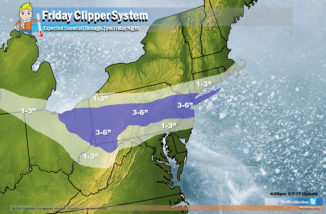
Two snow events will be arriving in the eastern United States in the coming days; the first will bring accumulating snow to a relatively narrow area stretching from Michigan to New York on Friday; the second will bring snow somewhere in the eastern US on Sunday, although those details still need to be sorted out.
While Sunday’s storm could be the more significant of the two, we need to deal with a fast-moving, weaker system later Thursday and Friday. A weak low pressure system originating in Canada, commonly referred to as a “clipper system”, will approach the Mid Atlantic Thursday night and exit the northeast on Friday. This system will have limited cold air and moisture to work with; as a result, precipitation will be light, and for many it’ll be in liquid form. North of I-195 and south of I-80 in New Jersey, west through Pennsylvania between I-80 and I-276/76, an 3-4″ of snow may fall by Friday evening, with some isolated amounts of 5″ possible in the higher terrain of central and western Pennsylvania and north central West Virginia. Lighter amounts of an inch or two will accumulate above and below this area. Further south, mainly light rain is possible which could end briefly as a period of wet snow with little to no accumulations.
As our map shows, we expect no accumulations from Friday’s storm over extreme southern New Jersey, Delaware, much of Maryland, and almost all of Virginia.
That could change with Sunday’s system. The clipper system on Friday will help usher in a significantly colder air mass into the eastern US to close out the week and chill down the weekend. The strength of this high, along with the overall atmospheric set-up over the US, will also determine where Sunday’s system travels. Highs will generally be 10-15 degrees below normal across much of the Northeast and Mid Atlantic on Saturday.
A few days ago, the European ECMWF forecast model was calling for an all-out blizzard for portions of the eastern United States –a solution we quickly discounted. But it along with other guidance, such as the American GFS forecast model, has come around with more reasonable solutions. While not a blizzard by any means, a significant snowfall is very possible.
Where that snowfall could be remains highly questionable. Subsequent forecast guidance has suggested that the storm track will sag south, which would favor areas like Virginia Beach getting snow over places like New York City. It is just too soon to know with certainty where Sunday’s storm will drop snow.
There are two primary possible scenarios for this Sunday storm.
One possibility is the cold high pressure system moving in on Saturday will help suppress Sunday’s storm system to the south. Similar to a scenario that happened in January, this could bring heavy snow to portions of Virginia, especially the Hampton Roads / Virginia Beach region. Snow totals will drastically drop off to the north in this scenario, with Cape May, New Jersey on the northern fringe of accumulating snow. This scenario is supported by the latest afternoon guidance from both the European ECMWF and American GFS forecast models.
The other scenario suggests that the cold high pressure system won’t be as strong; this would allow the storm system on Sunday to move closer up the northeast coast. This would shift the axis of heavier precipitation further north, but it would also bring the rain/snow line further north too. If such a scenario were to unfold, Pennsylvania and New Jersey would see the heaviest snow, with accumulating snow reaching north along the I-95 corridor, perhaps as far north as Boston. The rain/snow line would flirt with the Pennsylvania/Maryland border and southern New Jersey, keeping any snow totals in those areas low.
Until more of that atmospheric data is sampled, it is still too early to say which scenario will unfold. It is also too early to say which forecast model is “right” or “wrong”, especially with that data not yet ingested by the models. More data will come in over the next 24-48 hours which will help us improve the weekend forecast.
To recap:
- A relatively weak clipper system will bring light precipitation to portions of the northern Mid Atlantic later Thursday into Friday.
- Upwards of 3-4″ is possible across central Pennsylvania into central and northern New Jersey and the New York City metro area by the time the snow ends Friday PM.
- Some isolated 5″ amounts are possible in the highest terrain of Pennsylvania and West Virginia.
- Roads will be slick within the accumulation zone, especially during the PM drive home Friday.
- This clipper system will help usher in a much colder air mass into the northeast.
- Depending how strong that high is and how strong a low will be to its south will be, a snow storm is likely somewhere along the east coast; it is just too soon to say where that accumulating snow will set-up.
- Forecast guidance is suggesting now that best chances for the heaviest, accumulating snow will be in southeastern Virginia. But until additional data comes in, such guidance can’t be treated as gospel.
- Additional data will be in over the next 24-48 hours, which will help meteorologists solidify the weekend forecast.