Weather conditions are forecast to be very unsettled in the eastern United States this Christmas; for now, it appears the best chances for a White Christmas will be well north and west of the heavily populated I-95 corridor in the Northeast. And while Santa Claus may be coming to town with a weather system with more wet than white, it looks like Old Man Winter will be visiting for the holidays, setting the stage for more potentially significant winter storms just after Christmas.
Early Christmas Eve, conditions will be dry in the Northeast. A cold front associated with Saturday’s weather system will push off the coast of the northeast, but stall in the southern Mid Atlantic. A strong high pressure ridge will help keep the weather clear on Christmas Eve in the region; however, it won’t last long. A strong vorticity maximum will reach the base of a longwave trough expected to set-up in the central US Sunday night. With the vorticity maximum entering that base, a wave of low pressure is expected to develop along the slowing front in the southern Mid Atlantic. As the vorticity maximum lifts northeastward, very favorable jet coupling should occur, promoting rapid cyclogenesis along the East Coast late Christmas Eve and Christmas Day.
Global forecast model guidance that meteorologists use to aid in forecasting has not been that helpful with the Christmas Day storm system. The two most widely used models, the American GFS and the European ECMWF, have not shown run-to-run consistency nor have they remotely aligned with each other in terms of timing and intensity of these systems. Based on model disagreement and conflict, forecast confidence in how the Christmas Day system remains very low at this time.
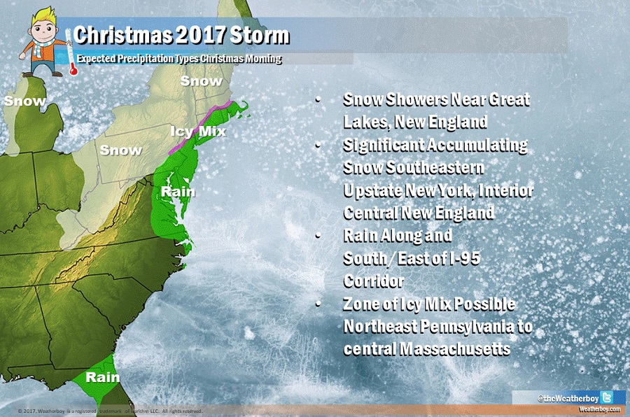
At this time, based on available data, it appears there is a reasonable chance for a precipitation event across portions of the eastern US late Christmas Eve and at least early Christmas Day. The best chance for snow is well north and west of the I-95 corridor, with risk of a moderate accumulating snowfall across southeastern upstate New York, extreme northwestern Connecticut, western Massachusetts, and portions of southern New Hampshire and Vermont. Further north into New England and further west towards the Great Lakes, snow showers and flurries are more likely. South of this region, along and south/east of the I-95 corridor, plain rain is expected to fall. In interior southern New England in between the snow and rain zones, an icy mix of sleet and freezing rain with the snow and plain rain may also fall.
There is a chance that this Christmas Day system will become better amplified and drag cold air further south and east into the I-95 corridor. If such a scenario were to unfold, snow would fall there too. For now, such a chance remains very low but does warrant continuous watching due to the high impacts any wintry precipitation on the holiday could produce.
Once the Christmas Day system departs, a broad and amplified longwave trough is left in its wake across the Northeast. Arctic cold will settle-in as surface high pressure builds from central Canada into the Mid Atlantic. Temperatures after Christmas into the middle of the week look to be 5-15 degrees below normal for the Northeast.
With cold air in place, other systems waiting in the wings may be able to produce significant snow near the I-95 corridor. Global forecast models have been hinting at such systems right before and right after New Year’s Eve. It is too soon to know with certainty how those systems could unfold, especially with many unknowns remaining around the earlier Christmas storm.
